
The Ringing Stone


Recumbent Stone Circle (Neolithic) - (Bronze Age)
Site Name The Ringing Stone
Classification Recumbent Stone Circle (Neolithic) - (Bronze Age)
Alternative Name(s) Haddock Circle; Arn Hill; Eron Stone
Canmore ID 17827
Site Number NJ54NW 12
NGR NJ 5316 4564
Datum OSGB36 - NGR
Permalink http://canmore.org.uk/site/17827


- Council Aberdeenshire
- Parish Cairnie
- Former Region Grampian
- Former District Gordon
- Former County Aberdeenshire
NJ54NW 12 5316 4564.
(NJ 5316 4565) Stone Circle (NR) (Remains of)
(NJ 5315 4564) Iron Stone (NR)
OS 6" map, Aberdeenshire, 2nd ed., (1902)
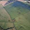
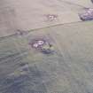
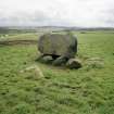
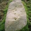
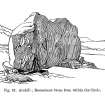
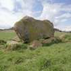
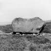
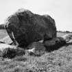
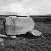
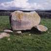
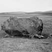
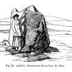
A very distinct artificial mound, with four great stones, crowning a hill 400ft high. Two of the stones are prone on the slope of the mound, the third appears to have been moved off it entirely, while the fourth is the great Recumbent Stone poised securely upon several small flat blocks, this stone is called the Iron Stone, which gives off a clear metallic tone when struck. It is set absolutely vertical, on a base 8ft 10" long by 3ft 4" broad. Its extreme length is 11ft 7" and it stands 10" clear off the ground. There are traces of much weathered concentric rings on the NE, which may be artificial. Two other stones shown on the ground plan are the remains of an interior setting. They lie 9ft inward from the west end of the Recumbent Stone. All this western portion has been ploughed flat, so that the bank of the mound, the base of which on the east is fully 6ft below the true summit, here disappears. The prostrate block of whinstone on the extreme NW, measures 6ft 2" by 2ft 7" by 1ft 3". Of the other two, the one on the N measures 8ft by 2ft by 1ft 8". A space of 17ft 6" separates it from the other fallen block, the size of which is much the same. The conjectural diameter of the circle is 60ft.
F R Coles 1902.
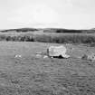
There is a low mound contained within the stone circle the ground rising from the stones to the centre. Estimated height from the top of the mound to ground level at base of stones 4t.
OS Reviser (TGR) 23 September 1955.
The remains of Recumbent Stone Circle and Mound are as described by Coles (1902); except that one of the eastern stones appears to have been placed in position recently and only one of the internal stones can be seen protruding from the mound.
Surveyed at 1/2500.
Visited by OS (NKB) 5 February 1964.
Field Visit (5 April 2005)
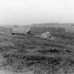
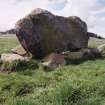
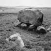
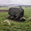
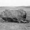
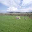
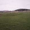
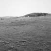
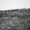
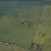
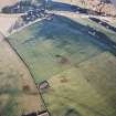
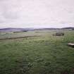
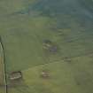
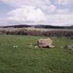
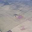
This grass-grown recumbent stone circle occupies a low rise on the NE spur of the Hill of Cormalet, a prominent position overlooking the valley of the River Deveron and its confluence with the River Isla. The circle itself has been reduced to no more than five stones, of which the recumbent is the only one still standing, but within the interior there is a cairn measuring about 20m in diameter by up to 1m in height. The recumbent block (2) stands on the SSW and measures about 3.5m in length by 1.7m in height. Its summit is uneven, rising into pronounced peaks at either end, and exhibits three long striae that may have been incised with a sharp implement. These contrast with a series of concentric grooves on the stone’s inner face that are clearly natural (Coles 1902, 572–3; Ritchie 1918, 111–2). Poaching and subsequent erosion around the foot of the stone has exposed one long stone sleeper beneath its WNW end and two shorter blocks supporting its ESE end. Both flankers are missing, and of the other stones lying around the perimeter of the internal cairn, only that on the NW (D), is certainly an orthostat of the circle (see below), now situated in the bottom of an eroded hollow. The position of the recumbent suggests that the ring of orthostats lay some 2m beyond the edge of the internal cairn, which on the E tails off into a low natural scarp. A single possible kerbstone can be seen on the edge of the cairn to the rear of the recumbent, but a second previously noted adjacent to it is no longer visible (Coles 1902, 573). On the day of the survey a fist-sized quartz pebble was observed in churned soil 3m E of the recumbent.
Visited by RCAHMS (ATW and KHJM)
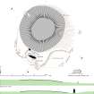
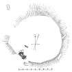
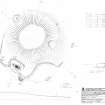
Measured Survey (5 April 2005)
RCAHMS surveyed the remains of the Ringing Stone recumbent stone circle on 5 April 2005 with plane table and alidade producing a plan and sections of the site and an elevation of the recumbent stone at a scale of 1:100. The plan, sections and elevation were used as the basis for an illustration, produced in ink and finished in vector graphics software, that was published at a scale of 1:250 (Welfare 2011, 440).

