
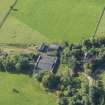
Mains Of Mayen


Farmstead (19th Century), Lairds House (17th Century), Sundial (Period Unknown)(Possible)
Site Name Mains Of Mayen
Classification Farmstead (19th Century), Lairds House (17th Century), Sundial (Period Unknown)(Possible)
Alternative Name(s) Mayen Castle; Mayen House Policies; Mayen House, Steading; Old Mayen
Canmore ID 17812
Site Number NJ54NE 24.01
NGR NJ 57465 47769
NGR Description NJ 57465 47769 and NJ 5754 4775
Datum OSGB36 - NGR
Permalink http://canmore.org.uk/site/17812


- Council Moray
- Parish Rothiemay
- Former Region Grampian
- Former District Moray
- Former County Banffshire
NJ54NE 24.01 57465 47769 and 5754 4775
Not to be confused with Mayen House (NJ 5798 4787), for which see NJ54NE 24.
(Location cited as NJ 5747 4777). A restored 17th century house with a date stone, 1680.
Visited by OS 8 September 1964.
The sundial depicted in MS 5741/8/7 was removed from Davidston near Huntly, to Old Mayen, where it was photographed in 1990, but it is not known whether it is still there. (A Cassells, 28 January 2010).
EXTERNAL REFERENCE:
Scottish Records Office
GD 44/Sec 51/385
Estimate for additional work. It amounts to £166.8.0
1783
Photographic Survey (7 September 1958)
Photographic survey by the Scottish National Buildings Record/Ministry of Works in September 1958.

