
Following the launch of trove.scot in February 2025 we are now planning the retiral of some of our webservices. Canmore will be switched off on 24th June 2025. Information about the closure can be found on the HES website: Retiral of HES web services | Historic Environment Scotland
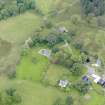
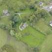
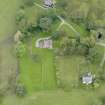
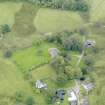
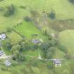
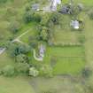
Barscobe Farm


Building(S) (Period Unassigned), Farmstead (Period Unassigned)
Site Name Barscobe Farm
Classification Building(S) (Period Unassigned), Farmstead (Period Unassigned)
Canmore ID 177726
Site Number NX68SE 1.03
NGR NX 66070 80628
NGR Description and NX 6607 8059
Datum OSGB36 - NGR
Permalink http://canmore.org.uk/site/177726


- Council Dumfries And Galloway
- Parish Balmaclellan
- Former Region Dumfries And Galloway
- Former District Stewartry
- Former County Kirkcudbrightshire
NX68SE 1.03 6607 8083 and 6607 8059
Two unroofed buildings, one of which is annotated 'Ruin' aredepicted on the 1st edition of the OS 6-inch map (Kirkcudbrightshire 1854, sheet 16). The current farmstaed (NX68SE 1.01) is shown on the current edition of the OS 1:10000 map (1982).
Information from RCAHMS (AKK) 16 December 1999.
NX68SE 1.03 66070 80628 Farm
NX68SE 1.00 65972 80640 Castle
NX68SE 1.01 66050 80578 Farm, Panel
NX68SE 1.02 66170 80455 House
NX68SE 1.04 65996 80716 Castle Cottage

