
Pricing Change
New pricing for orders of material from this site will come into place shortly. Charges for supply of digital images, digitisation on demand, prints and licensing will be altered.
Upcoming Maintenance
Please be advised that this website will undergo scheduled maintenance on the following dates:
Thursday, 9 January: 11:00 AM - 3:00 PM
Thursday, 23 January: 11:00 AM - 3:00 PM
Thursday, 30 January: 11:00 AM - 3:00 PM
During these times, some functionality such as image purchasing may be temporarily unavailable. We apologise for any inconvenience this may cause.
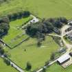
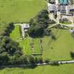
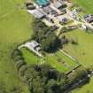
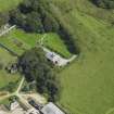
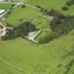
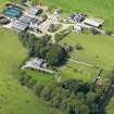
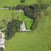
Borgue House


Farmstead (Period Unassigned)
Site Name Borgue House
Classification Farmstead (Period Unassigned)
Alternative Name(s) Low Borgue
Canmore ID 177302
Site Number NX64NW 83
NGR NX 6328 4816
Datum OSGB36 - NGR
Permalink http://canmore.org.uk/site/177302


- Council Dumfries And Galloway
- Parish Borgue
- Former Region Dumfries And Galloway
- Former District Stewartry
- Former County Kirkcudbrightshire
Note
A farmstead, comprising six roofed and two partially roofed buildings, one of which is annotated 'Ruin' is depicted on the 1st edition of the OS 6-inch map (Kirkcudbrightshire 1854, sheet 50). Seven roofed buildings and one partially roofed building are shown on the current edition of the OS 1:10000 map (1984).
Information from RCAHMS (AKK) 27 June 2000.

