
Ardlair


Rig And Furrow (Medieval) - (Post Medieval)
Site Name Ardlair
Classification Rig And Furrow (Medieval) - (Post Medieval)
Canmore ID 17634
Site Number NJ52NE 28
NGR NJ 5524 2801
NGR Description Centred NJ 5524 2801
Datum OSGB36 - NGR
Permalink http://canmore.org.uk/site/17634


- Council Aberdeenshire
- Parish Kennethmont
- Former Region Grampian
- Former District Gordon
- Former County Aberdeenshire
NJ52NE 28 centred 5524 2801
Noted during aerial reconnaissance.
Aberdeen Archaeological Surveys 1978.
(Location cited as NJ 552 280). Air photographs: AAS/94/02/G4/18-21.
NMRS, MS/712/21.
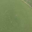
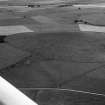
(Location cited as NJ 5524 2801). Air photography (AAS 1978, 1994 and 1998) has recorded an area of rig at an altitude of 220m OD. [Air photographic imagery listed].
NMRS, MS/712/35.
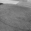
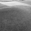
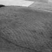
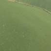
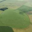
(Location changed to centred NJ 5524 2801). Extensive remains of rig-and-furrow cultivation can be seen on the summit of a low rounded hill, some 300m SW of Ardlair farmsteading (NJ52NE 93). They are clearly revealed by vertical aerial photographs (106G/SCOT/UK 130 5240-1, flown 25 June 1946) and on oblique photographs taken more recently (GRC/AAS 1978, 1981 and 1998).
The hill is depicted as wooded on the 1st edition of the OS 6-inch map (Aberdeenshire, 1st edition, 1870, sheet xliii), but the trees were felled before the end of the 19th century (OS 6-inch map, Aberdeenshire, 2nd edition, 1901, sheet xliii.NE). The land has since been ploughed but it is currently under pasture.
Visited by RCAHMS (JRS, IF), 4 April 1996

