
Candle Hill


Cup Marked Stone (Prehistoric), Recumbent Stone Circle (Neolithic) - (Bronze Age), Roundhouse (Prehistoric)
Site Name Candle Hill
Classification Cup Marked Stone (Prehistoric), Recumbent Stone Circle (Neolithic) - (Bronze Age), Roundhouse (Prehistoric)
Alternative Name(s) Candlehill; Candle Stane; Coldhome
Canmore ID 17615
Site Number NJ52NE 10
NGR NJ 5991 2997
Datum OSGB36 - NGR
Permalink http://canmore.org.uk/site/17615


- Council Aberdeenshire
- Parish Insch
- Former Region Grampian
- Former District Gordon
- Former County Aberdeenshire
NJ52NE 10 5991 2997
For adjacent quarry and rig (also recorded by Coles 1902), see NJ52NE 51.
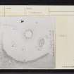
(NJ 5991 2997) Stone circle (NR) Candle Stane (NAT)
OS 6" map, (1959)
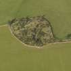
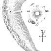
A recumbent stone circle 43 feet in diameter, surrounding a very well-defined central cairn 28 feet in daimeter. It consisted originally of eight stones, one of which has gone. Only one stone is standing; height 4 1/2 feet, named the Candle Stane, according to the Ordnance Survey Name Book (ONB, 1866). The recumbent stone is 13 3/4 feet long, 6 1/2 feet broad and 22 inches thick. Its fallen W flanker is 9 feet long and the E one is 6 1/2 feet long, and the other stones vary from 8 3/4 feet to 6 feet long. The circle stands in a conspicuous position with a trench like quarry on its west side, Keiller(1934) writes of the exquisitely worked wide curve on the inner faces of the flanking stones made to facilitate the lowering of the recumbent stone to its final position.
F R Coles 1902; J Ritchie 1917; A Keiller 1934; Name Book 1866.
A recumbent stone circle generally as described and planned above. Apart from the recumbent stone and two fallen flankers, five other stones remains, all displaced except for the Candle Stane. There are two possible cup marks on the E flanker and two further indistinct examples on the westernmost stone. The central cairn is c 7.0m in diameter and 1.0m high. Some spoil from the adjacent quarry has encroached into the
W side of the circle.
Revised at 1/2500.
Visited by OS (NKB) 21 September 1967.
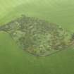
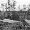
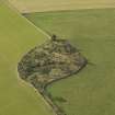
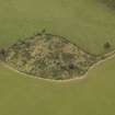
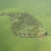
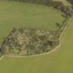
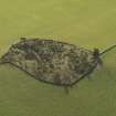
This recumbent stone circle is situated in an area of whin, broom and wild raspberries on the summit of a small hill at an altitude of 267m OD.
NMRS, MS/712/52, visited 16 November 1977.
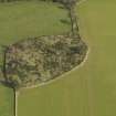
Excavation was carried out by EUCFA in October 1996 in response to the exposure during unauthorised quarrying of postholes with charcoal-rich fills. Hand-stripping of an irregular area of about 60 sq m within the NW quadrant revealed fourteen features which were totally excavated. These included a length of shallow curvilinear slot, a large and shallow stone-filled pit, a single stakehole and between three and eleven postholes.
Magnetic susceptibility survey revealed no evidence for the presence of a funerary pyre in this part of the monument. Flotation treatment of four soil samples produced sufficient charcoal for radiocarbon assay, but had little potential for the recovery of pollen. No artefacts were recovered in excavation.
The features were interpreted as the remains of a circular timber structure to the SW of the recumbent stone circle, the curvilinear slot possibly representing a ring-groove house of about 11m diameter. The juxtaposition of timber structures and stone circle was noted and the possibility was considered that these remains represent the re-use of an earlier (ritual) site by later settlement.
NMRS, MS/726/131.
(Location cited as NJ 599 299). The Candle Stane is part of a scheduled ancient monument comprising a recumbent stone circle surrounding a well-defined central cairn, situated on a hilltop adjacent to an abandoned quarry. Recent quarrying to the E of the site exposed a section which revealed post-holes with charcoal-stained fills. Between this section and the stone circle a further area had been stripped of topsoil in advance of further quarrying.
In October 1996 an area of about 60 sq m was cleaned to subsoil, revealing a suite of archaeologica features. A segment of shallow, curving slot, possibly a palisade, ran from the S baulk for a length of c. 7jm before being truncated by the recent quarrying. Along its inner margin, three charcoal-filled post-holes were regularly spaced at intervals of almost 2m. One of these had been partly destroyed by quarrying activity. All three contained packing stones. Eight other possible post-holes were identified, of roughly the same diameter as the post-holes beside the possible palisade, although shallower and lacking packing holes. Given the relatively small area examined, no obvious pattern could be discerned in these features. A shallow stone-filled pit, almost 1m wide, was also identified.
A Data Structure Report is in preparation.
Sponsor: Historic Scotland.
K Cameron 1996.
NJ 599 299 The Candle Stane is a scheduled recumbent stone circle surrounding a well-defined central cairn. Recent quarrying to the E of the site exposed a section which revealed post-holes with charcoal-stained fills. Preliminary examination of this area was carried out in 1996 (DES 1996, 8) and a further area covering roughly 70m2 was excavated in January 1997.
The excavation located the remains of a circular timber structure to the SW of the recumbent stone circle. The area had suffered extensive damage from quarrying prior to its recognition as an archaeological site, and therefore only 40?45% of the original structure remained. The structure was defined by a ring-groove which if extrapolated would be c 15.5m in diameter. The remains of three concentric rings of post-holes were located. The entranceway to the structure was massively built; had this structure been roofed, this could have formed a porch. Internal features included a single large stone-filled pit and a suite of stake-holes located near the centre of the structure.
A report will be lodged with the NMRS.
Sponsor: Historic Scotland.
K Cameron 1997.
Further excavation was conducted by EUCFA in January 1997 and opened an area of about 70 sq m immediately SE of that opened in 1996, on the NE, E and SSE of the circle.
The partial remains were exposed of a circular timber structure with a suggested diameter of about 15.5m which was defined by a ring-groove and had largely been destroyed by quarrying. A series of eight evenly-spaced postholes was identified within the groove, nd an arc of six further postholes was interpreted as a former inner ring. There was a complex entrance-structure on the SE, and internal features included a large and shallow stone spread, a series of near-central stakeholes, and a possible third ring of boulders.
No artifacts were recovered and the chronology of the structure remains unclear pending possible radiocarbon dating of charcoal recovered from some of the features. The initial interpretation of the structure as the remains of a roundhouse is, however, confirmed.
NMRS, MS/716/109.
Excavations undertaken by the Centre for Field Archaeology (CFA) to the south-west of the recumbent stone circle at the Candle Stane, near Insch, Aberdeenshire, revealed the remains of a large circular timber structure. The area had suffered extensive damage from quarrying prior to its recognition as an archaeological site and therefore less than half the relevant area remained. The structure was defined by a ring-groove that would have been c.15.5m in diameter; it enclosed three near concentric rings of post-holes. Charcoal from these features was radiocarbon dated to the first millennium BC. The entranceway to the structure was massively built and, had the structure been roofed, formed a porch. Internal features included a large stone-filled pit and a suite of stake-holes located towards the centre of the structure. No artefacts were recovered.
K Cameron 1999
Scheduled as Candle Stane, Coldhome.
Information from Historic Scotland, scheduling document dated 20 June 2002.
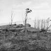
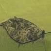
This recumbent stone circle is situated in scrub woodland on the summit of a low hill some 340m E of Coldhome farmsteading (NJ52NE 75). Eight stones survive, including the recumbent and its flankers, but with the exception of a small slab on the NE, which is sometimes known as the Candle Stone, all are now lying prone. The interior of the circle, which measures about 13m in diameter, is largely obscured by a spoil-heap from a disused quarry to the W, but a small exposure of possible cairn material was visible on the date of visit immediately behind the recumbent.
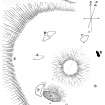
The recumbent and its flankers have fallen back into the interior, the recumbent itself measuring 4m in length by 2.2m in breadth (originally about 2m in height) and 0.6m in thickness. At least six cupmarks are visible close to its SW edge (originally the bottom of its outer face). The W flanker measures 2.6m in length by 1.15m in breadth and 0.5m in thickness, and the E flanker at least 2.05m by 0.95m and 0.3m in thickness. The upper surface of the latter (originally the outer face) bears at least three cupmarks, two of which measure up to 100mm in diameter. The slab standing on the NE measures 1.2m in breadth by 0.4m in thickness at ground-level and 1.4m in height. The other four, one of which lies on the ENE and the other three around the NW arc, are partly buried and were not measured. One of them appears to have been broken up.
Visited by RCAHMS (JRS, IF), 2 April 1996.
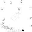
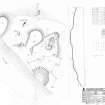
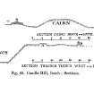
Measured Survey (18 November 1996)
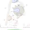
RCAHMS surveyed the remains of Candle Hill recumbent stone circle on 18 November 1996 with plane table and alidade producing a plan of the site at a scale of 1:100. The site was revisited on 7 July 1999 and a section and further additions were made to the drawing. The plan and section were redrawn in ink and used as the basis for an illustration produced in vector graphics software and published at a scale of 1:250 (Welfare 2011, 323).
Project (October 1996 - January 1997)
Excavations undertaken by the Centre for Field Archaeology (CFA) to the south-west of the recumbent stone circle at the Candle Stane, near Insch, Aberdeenshire, revealed the remains of a large circular timber structure. The area had suffered extensive damage from quarrying prior to its recognition as an archaeological site and therefore less than half the relevant area remained. The structure was defined by a ring-groove that would have been c.15.5m in diameter; it enclosed three near concentric rings of post-holes. Charcoal from these features was radiocarbon dated to the first millennium BC. The entranceway to the structure was massively built and, had the structure been roofed, formed a porch. Internal features included a large stone-filled pit and a suite of stake-holes located towards the centre of the structure. No artefacts were recovered.
K Cameron 1999
Excavation (October 1996)
Excavation was carried out by EUCFA in October 1996 in response to the exposure during unauthorised quarrying of postholes with charcoal-rich fills. Hand-stripping of an irregular area of about 60 sq m within the NW quadrant revealed fourteen features which were totally excavated. These included a length of shallow curvilinear slot, a large and shallow stone-filled pit, a single stakehole and between three and eleven postholes.
The features were interpreted as the remains of a circular timber structure to the SW of the recumbent stone circle, the curvilinear slot possibly representing a ring-groove house of about 11m diameter. The juxtaposition of timber structures and stone circle was noted and the possibility was considered that these remains represent the re-use of an earlier (ritual) site by later settlement.
NMRS, MS/726/131.
Magnetic Susceptibility (October 1996)
Magnetic susceptibility survey revealed no evidence for the presence of a funerary pyre in this part of the monument. Flotation treatment of four soil samples produced sufficient charcoal for radiocarbon assay, but had little potential for the recovery of pollen. No artefacts were recovered in excavation.
NMRS, MS/726/131.
Excavation (January 1997)
Further excavation was conducted by EUCFA in January 1997 and opened an area of about 70 sq m immediately SE of that opened in 1996, on the NE, E and SSE of the circle.
The partial remains were exposed of a circular timber structure with a suggested diameter of about 15.5m which was defined by a ring-groove and had largely been destroyed by quarrying. A series of eight evenly-spaced postholes was identified within the groove, nd an arc of six further postholes was interpreted as a former inner ring. There was a complex entrance-structure on the SE, and internal features included a large and shallow stone spread, a series of near-central stakeholes, and a possible third ring of boulders.
No artifacts were recovered and the chronology of the structure remains unclear pending possible radiocarbon dating of charcoal recovered from some of the features. The initial interpretation of the structure as the remains of a roundhouse is, however, confirmed.
NMRS, MS/716/109.
Field Visit (7 July 1999)
This recumbent stone circle occupies a prominent position a little to the S of the summit of Candle Hill, lying in a grass-grown clearing in the rowan and broom scrub on the E side of an old quarry. Only the Candle Stane itself (5) is still standing, but another seven stones, including the recumbent and its flankers, lie prone around the circumference of a circle 15.5m in diameter; the spacing of the stones indicates that there were originally at least nine, and possibly ten. The recumbent (2), which is on the S, is a roughly trapezoidal slab on plan and has fallen onto its back. It measures some 4m in length by 2m in breadth and its upturned face exhibits a single cupmark near the SW corner. The even summit of the slab, which now forms its NW edge, bears another faint cupmark and two broad basins. Both flankers (1 & 3) have also fallen backwards, but their shapes suggest that they would have appeared to arch over the ends of the recumbent when the setting was upright; the E flanker (3) exhibits two cupmarks on its upturned face. The NW quarter of the ring is particularly well defined, with the Candle Stane (5) on the N followed by an arc of three fallen orthostats (6–8) extending round to the W; the westernmost (8) exhibits two shallow cupmarks on its upper face. Another orthostat (4) lies displaced down the slope to the NE. The interior is dominated by a spoil-tip from the adjacent quarry, but the presence of an internal cairn beneath it is probably denoted by the slight swelling in the ground detectable in the drawn profile and a small exposure of closely packed stones immediately N of the recumbent.
Visited by RCAHMS (ATW and KHJM) 17 July 1999

