
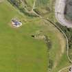
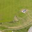
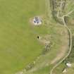
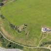
Dryland Croft


Farmstead (Period Unassigned)
Site Name Dryland Croft
Classification Farmstead (Period Unassigned)
Canmore ID 175517
Site Number NX14SW 35
NGR NX 1145 4386
Datum OSGB36 - NGR
Permalink http://canmore.org.uk/site/175517


- Council Dumfries And Galloway
- Parish Kirkmaiden
- Former Region Dumfries And Galloway
- Former District Wigtown
- Former County Wigtownshire
Note
A farmstead comprising one unroofed building annotated Ruins, two roofed buildings, one of which is a long building, and one enclosure is depicted on the 1st edition of the OS 6-inch map (Wigtonshire 1850, sheet 27). One roofed building is shown on the current edition of the OS 1:10000 map (1976).
Information from RCAHMS (SAH) 18 November 1999

