
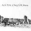
Old Keig


Recumbent Stone Circle (Neolithic) - (Bronze Age)
Site Name Old Keig
Classification Recumbent Stone Circle (Neolithic) - (Bronze Age)
Canmore ID 17530
Site Number NJ51NE 2
NGR NJ 5965 1939
Datum OSGB36 - NGR
Permalink http://canmore.org.uk/site/17530


!['Recumbent from [NNE] with 1 and 2'](http://i.rcahms.gov.uk/canmore/l/SC01924747.jpg)


!['Recumbent from [NNE] with 1 and 2'](http://i.rcahms.gov.uk/canmore/l/SC01221911.jpg)


!['Recumbent from [NNE] with 1 and 2'](http://i.rcahms.gov.uk/canmore/s/SC01924747.jpg)


!['Recumbent from [NNE] with 1 and 2'](http://i.rcahms.gov.uk/canmore/s/SC01221911.jpg)


First 100 images shown. See the Collections panel (below) for a link to all digital images.
- Council Aberdeenshire
- Parish Keig
- Former Region Grampian
- Former District Gordon
- Former County Aberdeenshire
NJ51NE 2 5965 1939.
(NJ 5965 1939) Stone Circle (NR) (Remains of).
OS 6" map, Aberdeenshire, 2nd ed., (1901)
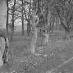
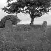
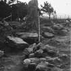
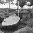
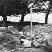
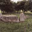
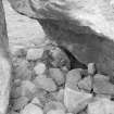
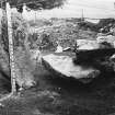
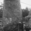
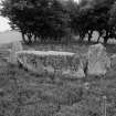
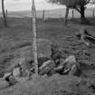
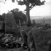
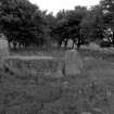
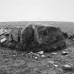
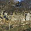
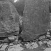
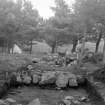
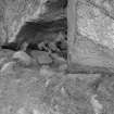
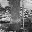
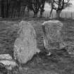
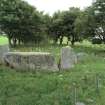
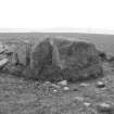
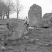
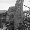
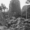
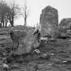
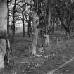
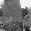
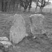
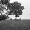
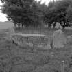
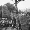
At Old Keig a recumbent stone circle situated on a slight crest on a ridge, and within a narrow windbelt. A recumbent stone, 16ft long on top, 6ft thick, 6 3/4ft high, two flankers, the westerly 5 1/4ft above the turf, the easterly 9 1/2ft, and a third orthostat, 9 1/2ft high, to the east, survive. Five other earth fast stones in the vicinity look as if they have been disturbed.
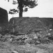
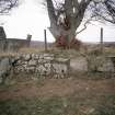
The recumbent stone and pillars stand in a more or less circular bank, composed of earth and stone, which merges into the dykes bounding the windbelt on either side and crosses the belt on the north. Here two large blocks projecting above the turf are loose, and two others lie prostrate outside the bank.
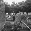
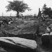
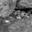
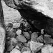
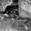
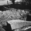
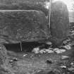
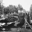
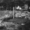
Excavations by Childe in 1932-33 revealed a bank of large stones, just under the turf in front of the recumbent and E flanker, extending for 7 ft towards the centre of the circle. The remains of an eccentrically placed ring cairn, which had been disturbed by operations in 1692, were uncovered. They comprised a kerb of large stones 15ins to 24ins, long forming a very rough semi-circle about 30 feet diameter, containing a disorderly collection of boulders. As a result 'flat-rimmed' pottery found during the excavations Childe's dated the monument to the Late Bronze/Early Iron Age but this view was challenged by Kilbride-Jones (1935) who regarded the pottery as secondary, and the very few beaker sherds, including one with burning-bone comb impressions, as presumably primary.
Finds, presented to the National Museum of Antiquities of Scotland (NMAS), included beaker potsherds, charcoal, minute fragments of cremated human bones and portions of three or more large flat-rimmed urns.
V G Childe 1933; 1934; H E Kilbride-Jones 1935; R J C Atkinson 1962; A S Henshall 1963.
Recumbent stone, easterly orthostat and bank remains as described. No trace of inner ring cairn or of stones in front of recumbent stone.
Surveyed at 1/2500.
Visited by OS (RL) 12 September 1968.
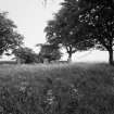
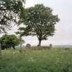
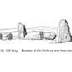
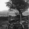
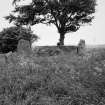
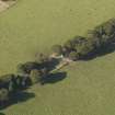
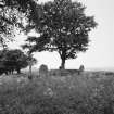
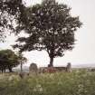
At once communal and anonymous, the essentially neolithic nature of the recumbent stone circle is perhaps nowhere better seen than at Old Keig where the circle, 20m in diameter, is now represented by a gigantic recumbent of sillimanite gneiss, two flankers and one other stone, standing on a low bank.
The circle is located on a very slight crest on rising ground with distant, sometimes magical, views over the Howe of Alford. The site was probably levelled and the enormous recumbent, which weighs 53 tons and is the largest known (4.9m by 2.1m by 2.0m) dragged from somewhere in the Don valley about 10km away. The last 1km would have been uphill at a gradient of 1:14, requiring well over 100 people.
Prior to the building of the eccentrically-placed ring cairn, a small timber structure (similar to that at Loanhead of Daviot, NJ72NW 1) may have stood for a short time in the central area.
I A G Shepherd 1986.
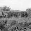
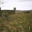
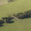
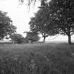
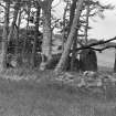
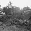
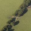
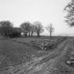
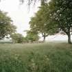
This monument is situated in a grassy shelterbelt on the crest of a ridge at an altitude of 210m OD. The ground falls away on all sides and there is an open aspect to the S. The massive recumbent stone and flankers are its most impressive feature, there being little trace of any internal features. It has been tidied up since 1975 (the hole under the recumbent being filled with loose stones) and there are four small trees in the bank.
(GRC/AAS air photograph: AAS/86/05/S7/4. GRC/AAS ground photography also cited).
NMRS, MS/712/50, visited 20 May 1978.
Scheduled as Old Keig, stone circle.
Information from Historic Scotland, scheduling document dated 2 August 2001.
Excavation (27 June 1933 - 26 July 1933)
Excavated by Childe in 1933.
G V Childe 1933; 1934
Publication Account (1986)
At once communal and anonymous, the essentially neolithic nature of the recumbent stone circle is perhaps nowhere better seen than at Old Keig there the circle, 20 m in diameter, is now represented by a gigantic recumbent of sillimanite gneiss, two flankers and one other stone, standing on a low bank. The circle is located on a very slight crest on rising ground with distant, sometimes magical, views over the Howe of Alford. The site was probably levelled and the enormous recumbent, which weighs 53 tons and is the largest known (4.9m by 2.1m by 2.0m), dragged from somewhere in the Don valley about 10km away. The last 1km would have been uphill, at a gradient of 1 :14, requiring well over 100 people. Prior to the building of the eccentrically placed ring cairn, a small timber structure may have stood for a short time in the central area (cf Loanhead, no. 98).
Information from ‘Exploring Scotland’s Heritage: Grampian’, (1986).
Publication Account (1996)
At once communal and anonymous, the essentially neolithic nature of the recumbent stone circle is perhaps nowhere better seen than at Old Keig where the circle, 20m in diameter, is now represented by a gigantic recumbent of sillimanite gneiss, two Bankers and one other stone, standing on a low bank. The circle is located on a very slight crest on rising ground with distant, sometimes magical, views over the Howe of Alford. The site was probably levelled and the enormous recumbent, which weighs 53 tons and is the largest known (4.9m by 2.1m by 2.0m), dragged from somewhere in the Don valley about 10km away. The last 1km would have been uphill, at a gradient of 1:14, requiring well over 100 people. Prior to the building of the eccentrically placed ring cairn, a small timber structure may have stood for a short time in the central area (cf Loanhead, no. 98).
Information from ‘Exploring Scotland’s Heritage: Aberdeen and North-East Scotland’, (1996).
Field Visit (15 June 1998)
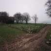
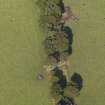
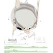
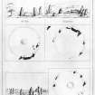
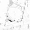
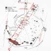
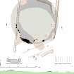
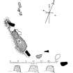
The imposing recumbent at Old Keig is one of the most enduring images of recumbent stone circles, not only embodying the scale of engineering required to build these monuments, but also the history of their exploration. Incorporated into a shelterbelt dropping down the crest of the SSW spur of the Hill of Airlie, it is situated on a minor rise immediately N of a track cutting through to link the fields to either side. While the fields are improved and featureless, within the narrow strip of woodland part of an earlier rig-system is preserved, the individual rigs descending the slope as a flight of low lynchets or terraces to either side of the circle. By the time it had been incorporated into the plantation the circle had been reduced to the recumbent setting on the SSW (1–3) and a single orthostat on the SSE (4), but as a result of the excavations initiated by Gordon Childe in 1932 (1933; 1934) three other fallen orthostats were identified, one of which can be seen lying on the E (5) and the other two on the N (6–7). The size of the circle is commensurate with that of its recumbent and is about 27m in diameter. The massive recumbent (2) measures some 5.45m in length by 1.75m in height, with an even summit set roughly horizontal. The flankers (1 & 3) stand about 2.2m and 2.3m high respectively and present very different profiles on the façade of the setting, the western being a relatively slender pointed slab and the eastern broader and subrectangular. In both cases they stand back from the leading face of the recumbent, but whereas the W flanker extends the alignment of the recumbent, the E flanker is turned slightly to trace the arc of the circle. With so many of the orthostats fallen and missing it is difficult to demonstrate that the stones of the circle were graded, but there is no doubt that the top of the sole orthostat remaining upright (4) is lower than its neighbouring flanker and there was probably a reduction in height to the fallen slab adjacent to it on the N (5).
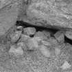
Within the interior there is a heavily-robbed cairn, now largely reduced to bands of rubble extending across the plantation on the N and SW and spread up to 26m across from NNE to SSW. The seven kerbstones visible in the SW quadrant, coupled with at least another thirteen Childe discovered, most of them lying prostrate beneath the turf on the S and N, indicate that the cairn measures about 22m in diameter, expanding to 24m on the SSW where the kerb turns out to meet the rear of the recumbent setting; a prostrate slab within the ring on the SE (A) is one of the fallen kerbstones uncovered by Childe, and what are probably another ten have been incorporated into the dykes of the plantation. The seven that remain in place are not evenly graded in height, but the slabs about 1m broad and 1.2m high immediately behind the E flanker are significantly larger than those in the order of 0.75m high noted during the excavation on the N side of the ring; there can be little doubt that the kerb adjacent to the recumbent was an impressive setting of stones in its own right. In so far as Childe could detect, the cairn material had formed a ring-bank about 16.8m in internal diameter, though it is not clear from his account whether any of the large stones he found towards the edge of the bank on the SW and N were the remains of a formal inner kerb; it is perhaps more likely that this was simply an edge created by the pattern of stone-robbing. Nevertheless, a low mound of cairn material a little over 8m across survived in the centre and beneath this Childe discovered a patch of burnt ground measuring almost 4m by 2m and, eccentrically to this, a spread of cremated bones and pottery, the latter representing up to three separate vessels; an elongated pit had been cut through the burnt patch. Two other smaller areas of burning were identified in the area within the surviving bank of cairn material.
Visited by RCAHMS (ATW and KHJM) 15 June 1998
Field Visit (7 February 2017)
The plan taken in 1998 was amended to illustrate the internal scarps of rubble resulting from heavy robbing in antiquity and restoration following Childe's excavations in the 1930s.
Visited by HES, Survey and Recording (ATW and AMcC), 7 February 2017.

