
Following the launch of trove.scot in February 2025 we are now planning the retiral of some of our webservices. Canmore will be switched off on 24th June 2025. Information about the closure can be found on the HES website: Retiral of HES web services | Historic Environment Scotland
Athelstaneford Mains


Farmhouse (19th Century), Farmstead (19th Century) (1860)
Site Name Athelstaneford Mains
Classification Farmhouse (19th Century), Farmstead (19th Century) (1860)
Canmore ID 174526
Site Number NT57NW 117
NGR NT 54093 77227
Datum OSGB36 - NGR
Permalink http://canmore.org.uk/site/174526


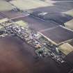


- Council East Lothian
- Parish Athelstaneford
- Former Region Lothian
- Former District East Lothian
- Former County East Lothian
NT57NW 117 54093 77227
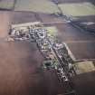
A RCAHMS photographic survey was conducted following proposal to demolish part of the agricultural buildings.
Visited by RCAHMS(MKO), September 1997.

