
Following the launch of trove.scot in February 2025 we are now planning the retiral of some of our webservices. Canmore will be switched off on 24th June 2025. Information about the closure can be found on the HES website: Retiral of HES web services | Historic Environment Scotland
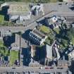
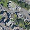
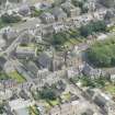
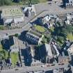
Wick, Dempster Street, Wick Central Church


Church (Mid 19th Century) (1853)
Site Name Wick, Dempster Street, Wick Central Church
Classification Church (Mid 19th Century) (1853)
Alternative Name(s) Pultneytown Central United Free Church; Pultneytown Free Church; Wick Baptist Church; Church Of Scotland
Canmore ID 174209
Site Number ND35SE 206
NGR ND 36440 50551
Datum OSGB36 - NGR
Permalink http://canmore.org.uk/site/174209


- Council Highland
- Parish Wick
- Former Region Highland
- Former District Caithness
- Former County Caithness
ND35SE 206 36436 50456
Church (C of S) [NAT]
OS 1:12500 map, 1972.
Aerial (14 August 2013)
Note (9 June 2025)
A Free church is depicted on the 1st edition of the OS 6-inch map (Caithness 1873, sheet XXV.5) and is shown on OS Mastermap. The church closed in 1990 but reopened as a Baptist church in 1997.
Information from HES 9 June 2025

