
Pricing Change
New pricing for orders of material from this site will come into place shortly. Charges for supply of digital images, digitisation on demand, prints and licensing will be altered.
Scottack


Building (Period Unassigned)
Site Name Scottack
Classification Building (Period Unassigned)
Canmore ID 173951
Site Number NH74NW 95
NGR NH 7357 4974
Datum OSGB36 - NGR
Permalink http://canmore.org.uk/site/173951


- Council Highland
- Parish Petty
- Former Region Highland
- Former District Inverness
- Former County Inverness-shire
NH74NW 95 7357 4974
A single unroofed building is depicted on the 1st edition of the OS 6-inch map (Inverness-shire 1874, sheet iv), but it is not shown on the current edition of the OS 1:10000 map (1982).
Information from RCAHMS (SAH) 6 June 1996
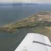
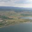
NH 735 497 The site of the tide mill of Petty was surveyed as part of a wider study into the history of Petty Church and its environs. The site is previously recorded in the NMRS (NH74NW 95) as a single building.
The site is a rectangular building with sluice and an associated dyke and possibly two other structures. A documentary study revealed a date of use, both as a mill and a dwelling, from late 17th to mid-19th century.
Full report lodged with Highland SMR and the NMRS.
S Farrell 2001

