
Following the launch of trove.scot in February 2025 we are now planning the retiral of some of our webservices. Canmore will be switched off on 24th June 2025. Information about the closure can be found on the HES website: Retiral of HES web services | Historic Environment Scotland
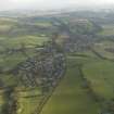
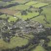
Saline Village, General


General View (Period Unassigned), Village (Period Unassigned)
Site Name Saline Village, General
Classification General View (Period Unassigned), Village (Period Unassigned)
Canmore ID 173734
Site Number NT09SW 73
NGR NT 02238 92468
NGR Description Centred NT 02238 92468
Datum OSGB36 - NGR
Permalink http://canmore.org.uk/site/173734


- Council Fife
- Parish Saline
- Former Region Fife
- Former District Dunfermline
- Former County Fife
NT09SW 104 centred 02238 92468
A village siuated on the B914 road about 7Km NW of Dunfermline. Three main streets, North Road, West Road and Main Street with a mainly 19th century core. Some pre-19th century buildings, notably Craig House and the Church. 20th and 21st century expansion to NW and SE.
The village is depicted on the 1st Edition of the OS 6-inch map (Fife & Kinross, 1865, sheet 34), which shows ribbon development along the three roads. The Ordnance Survey Object Name Book (ONB), describes the village as 'A considerable village about 6 miles from Dunfermline. It has two churches(one Free and the Established), two schools (one parochial and the other private), a Post Office, an Inn, two public houses, a burial ground and several private residences. The remainder of the viallge is principally cottages the property of Sir Robert Preston. About half a mile to the E is the ruins of Killernie Castle. There are no other antiquities about the village' (Name Book 1864).
Information from RCAHMS (DE), April 2009

