
Pricing Change
New pricing for orders of material from this site will come into place shortly. Charges for supply of digital images, digitisation on demand, prints and licensing will be altered.
Upcoming Maintenance
Please be advised that this website will undergo scheduled maintenance on the following dates:
Thursday, 9 January: 11:00 AM - 3:00 PM
Thursday, 23 January: 11:00 AM - 3:00 PM
Thursday, 30 January: 11:00 AM - 3:00 PM
During these times, some functionality such as image purchasing may be temporarily unavailable. We apologise for any inconvenience this may cause.
Margcraggan


Farmstead (Period Unassigned)
Site Name Margcraggan
Classification Farmstead (Period Unassigned)
Alternative Name(s) Wester Carwhin; Carie
Canmore ID 173376
Site Number NN63NW 84
NGR NN 63680 36643
Datum OSGB36 - NGR
Permalink http://canmore.org.uk/site/173376


- Council Perth And Kinross
- Parish Kenmore (Perth And Kinross)
- Former Region Tayside
- Former District Perth And Kinross
- Former County Perthshire
NN63NW 84 63680 36643
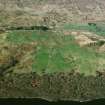
This farmstead stands in enclosed pasture on the SSE-facing slopes above Loch Tay, and immediately S of a rocky knoll. It comprises three buildings and an enclosure, which are approached from the NE by a hollowed trackway flanked by a pair of drystone dykes. Two buildings stand on the N side of the trackway, while the third stands to the S, within the enclosure.
The largest building is the easternmost of the two on the N side of the trackway (BL00 116). It measures 14.8m from ENE to WSW by 4.1m transversely within faced rubble walls 0.8m in thickness, which stand up to 1.7m high at the sides and 4m high at the gable ends. It has been divided into two unequal compartments. The larger WSW compartment has an entrance on the SSE, while the smaller compartment has had an entrance in each side wall, though that on the NNW has been blocked up. The latter compartment also has a blocked window near the apex of the ENE gable. The two entrances on the SSE side open onto a terrace raised above the trackway. An outshot extends 2.4m to the ENE and there is a privy attached to the WSW gable. Immediately to the WSW there is a two-compartment building, constructed in two phases (BL00 117). The original compartment measures 4.6m from NNW to SSE by 2.8m transversely within rubble walls 1m high, and it has a blocked entrance in the SSE end. The later compartment has been built against the WSW side of the first; it measures 6.5m by 3.2m and has an entrance on the SSE. The third building, which stands in a stone walled enclosure measuring 45m from NE to SW by 18m transversely, is aligned NW and SE and has opposed entrances, suggesting that it served as a barn (BL00 115). It measures 7.4m from NW to SE by 3.4m transversely within walls 1.9m high at the sides and 3.2m high at the NW gable.
A farmstead comprising two buildings and an enclosure (though with a layout quite different from that just described) is depicted at this location on John Farquharson's 1769 Survey of the North Side of Loch Tay (National Archives of Scotland, RHP 973/1, Plan 7), one of five settlements depicted on the farm of Wester Carwhin. The buildings described above are, however, depicted on the 1st edition of the OS 6-inch map (Perthshire 1867, sheet lxix), and again on the 2nd edition map (Perthshire 1900, sheet lxix SW). Both maps show all three buildings as roofed and both apply the name Margcraggan to this site. The site now lies on Carie farm.
(BL00 115-7, 2606)
Visited by RCAHMS (MFTR, ATW), 5 April 2000.

