
Pricing Change
New pricing for orders of material from this site will come into place shortly. Charges for supply of digital images, digitisation on demand, prints and licensing will be altered.
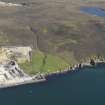
Kebister


Enclosure(S) (Period Unassigned), Hut Circle (Prehistoric)(Possible)
Site Name Kebister
Classification Enclosure(S) (Period Unassigned), Hut Circle (Prehistoric)(Possible)
Canmore ID 173116
Site Number HU44NE 16
NGR HU 4558 4513
Datum OSGB36 - NGR
Permalink http://canmore.org.uk/site/173116

- Council Shetland Islands
- Parish Tingwall
- Former Region Shetland Islands Area
- Former District Shetland
- Former County Shetland
HU44NE 16 4558 4513
A structure and two possibly associated enclosures are located at approximately 30m OD, near the S edge of the Kebister survey area, outwith the March Dyke (NO44NE 11.01), on rugged moorland immedieatly W of an area of extensive peat-cutting. The structure (Structure 24 in the published report) comprises a continuous heather-covered stoney-bank, 1m wide and 0.30m high, and is roughly circular. It underlies some 0.25-0.35m of peat, and is tentatively interpreted as a prehistoric building, conceivably a hut-circle. The two enclosures (Enclosures 8 and 9 in the published report) are located to its N and are represented by curvilinear stone banks, overlain by some 0.50m of peat.
O Owen and C Lowe 1999.
The excavation archive from Kebister has been catalogued. The archive consists of manuscripts, photographic material and drawings. Digital and audio archive is available and consists of drafts of the Kebister 1999 monograph, the stone catalogues, the key for the soil maps, mini data cartridges containing 'Kebister modified files' and a recorded conversation with Mr and Mrs Anderson.
Historic Scotland Archive Project (SW) 2001

