
Invershiel


Village (Period Unassigned)
Site Name Invershiel
Classification Village (Period Unassigned)
Canmore ID 172973
Site Number NG91NW 12
NGR NG 937 193
NGR Description Centred NG 937 193
Datum OSGB36 - NGR
Permalink http://canmore.org.uk/site/172973


- Council Highland
- Parish Glenshiel
- Former Region Highland
- Former District Skye And Lochalsh
- Former County Ross And Cromarty
Field Visit (15 February 1997 - 15 February 1997)
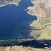
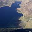
There are three distinct areas of settlement by the road which seem to form the Invershiel of the 19th century, as recorded on the 1st edition OS map. At the N end, by the pier, is Invershiel - now known as Kintail Lodge Hotel (NMRS NG91NW00 4). By the shore of Loch Duich to the S is a cluster of 3 or 4 buildings. Further S, along the shore, there is a cluster of 4 buildings and a sheepfold.
The 1841 census records 7 households at Invershiel.
Roy's survey of c1750 shows the township of Inversheel situated on the hillside some distance from the shore of Loch Duich. However, this archaeological survey failed to find any trace of settlement on the hillside and perhaps it is inaccurately located by Roy.
Bleau's map of 1654 marks 'Innersheyl' north of where the river Shiel flows into Loch Duich.
MacFarlane's transcript of Pont's notes of c1590 includes reference to Innersell - a mile S of Kildowich (St Dubhthach's church and graveyard).
Information from NTS: KIN048 (JH and JW) 15th February 1998
NTS Survey

