
Barflat


Circular Enclosure(S) (Period Unassigned), Beaker(S) (Period Unassigned)
Site Name Barflat
Classification Circular Enclosure(S) (Period Unassigned), Beaker(S) (Period Unassigned)
Alternative Name(s) Bareflat; Craw Stane
Canmore ID 17220
Site Number NJ42NE 54
NGR NJ 49700 26350
Datum OSGB36 - NGR
Permalink http://canmore.org.uk/site/17220


- Council Aberdeenshire
- Parish Rhynie
- Former Region Grampian
- Former District Gordon
- Former County Aberdeenshire
NJ42NE 54 4970 2635
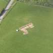
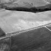
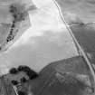
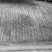
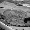
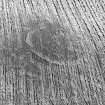
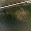
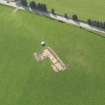
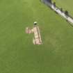
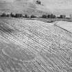
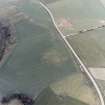
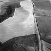
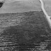
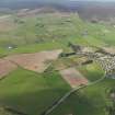
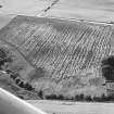
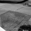
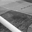
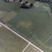
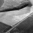
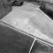
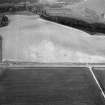
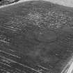
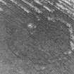
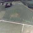
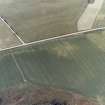
Cropmark of a circular enclosure centred around the Craw Stane (NJ42NE 35). It is formed of three concentric circles, which are probably ditched and palisaded.
Information from Mrs M Greig (Grampian Regional Council), 24 April 1995.
Air photographic imagery listed.
NMRS, MS/712/36.
Air photographs: AAS/94/11/G21/11-14.
NMRS, MS/712/21.
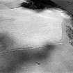
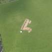
NJ 4974 2634 Several pieces of an All-Over Cord Beaker were found to be eroding from a cattle scrape to the immediate N of the Craw Stane (NJ42NE 35), a Pictish carved stone, and within the boundaries of the Barflat enclosure (NJ42NE 54), both of which are Scheduled Ancient Monuments. The remaining pieces of the Beaker were recovered in June 2005 and associated underlying features identified. A probable pit cut, which had been severely eroded, was identified in the face of the cattle scrape. No more pieces of the Beaker were recovered.
Archive to be deposited in NMRS.
Sponsor: HS
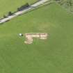
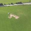
Aerial Photographic Transcription (8 November 1995)
An aerial transcription was produced from oblique aerial photographs. Information from Historic Environment Scotland (BM) 31 March 2017.
Note (8 April 2015 - 31 May 2016)
Cropmarks have revealed the site of a fortification now known to be of early medieval date on a low spur of a terrace above Rhynie old burial-ground, its position marked by the Pictish symbol stone known as the Craw Stane. In all, three concentric lines of defence can be seen on the aerial photographs, the two inner represented by ditches and the outermost by a palisade trench apparently accompanied by an internal line of pits. The innermost ditch, which is only intermittently visible, encloses an oval area measuring no more than 30m from NE to SW by 20m transversely (0.05ha), while the rather bolder mark of the second ditch, 4m in breadth and some 7m outside it, encloses an area measuring 45m by 32m (0.11ha). The enclosure formed by the palisade trench measures 62m by 48m (0.23ha). Excavations directed by Aberdeen University have concentrated on stripping and mapping the enclosures, coupled with more limited excavation. The palisade trench held squared planks with a supporting row of timbers in the pits to its rear and was evidently a timber rampart rather than a simple fence. Nevertheless, this work has demonstrated that all three circuits, while not necessarily directly contemporary with each other, are of early medieval date, with evidence of phases of destruction and reconstruction, and the presence of substantial rectangular timber buildings. The Craw Stane itself seems to have formed part of an elaborate entrance on the E. Artefacts recovered include sherds from probably two different types of imported Late Roman Amphorae of 6th-century date, a fragment of 6th-century continental glass, bronze and iron pins, metalworking moulds for pins and a brooch, glass-working and metalworking debris, iron tongs, an iron axe and amber beads.
Information from An Atlas of Hillforts of Great Britain and Ireland – 31 May 2016. Atlas of Hillforts SC2941

