
Pricing Change
New pricing for orders of material from this site will come into place shortly. Charges for supply of digital images, digitisation on demand, prints and licensing will be altered.
Wester Kiltyrie


Farmstead (Period Unassigned)
Site Name Wester Kiltyrie
Classification Farmstead (Period Unassigned)
Canmore ID 172170
Site Number NN63NW 75
NGR NN 62775 36213
Datum OSGB36 - NGR
Permalink http://canmore.org.uk/site/172170


- Council Perth And Kinross
- Parish Kenmore (Perth And Kinross)
- Former Region Tayside
- Former District Perth And Kinross
- Former County Perthshire
NN63NW 75 62775 36213.
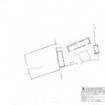
This well-preserved farmstead stands on a terrace above the N shore of Loch Tay, about 450m SSW of Kiltyrie farmhouse. To the S, a pasture field slopes towards the woodland fringing the loch, while the sparsely-wooded hillside rises, sharply at first, towards the N. The farmstead comprises four buildings arranged around a roughly rectangular yard, with an enclosure to the W and a fifth building on the rising ground to the N. The buildings are all roughly rectangular with squared corners, and are constructed of rubble bonded with clay (most of which has washed out). The side walls stand up to about 2m high, and most of the gable ends are largely intact, standing up to 4m high.
The principal building, a byre-dwelling on the N side of the yard, measures internally 21.9m from ENE to WSW by 4.1m transversely (BL00 1185). The E gable is almost complete, but the upper half of the WSW gable, and parts of both side walls, have collapsed. Traces of five pairs of cruck-slots are visible, though their spacing suggests that there were originally seven pairs in all. There are three entrances in the S wall, two opening into the E half of the building, one into the W half, and a slot set into the E jamb of the W entrance retains the rotted remains of a timber 'dook' to which the doorframe would have been secured.
The dwelling was at the W end of the building. Here there is a splayed and lintelled window in the N wall, opposite the entrance, and there were probably windows in the S wall to either side of the entrance, though only that to the E survives, again with its lintel in situ. The W gable has a built-in fireplace, over which there is a massive lintel, and there is a press in the SW corner. No internal partitions survive, but the surviving features are consistent with a layout comprising two principal rooms (one to either side of the entrance) with a smaller back room between them. No partition survives between house and byre, but its position may be marked by an edge-set slab, possibly the back-slab of a hearth, which measures about 1.2m in length, and protrudes from the ground in the centre of the building about 9.8m from the W wall. The floor of the E compartment has traces of two slab-lined drains, one leading to each of its two entrances.
Outside the building, a shallow drainage gully runs along the base of the rear wall, while the three entrances open onto a revetted terrace, about 5m broad. Below this, opposite the byre entrances, there is a rectangular midden, measuring about 9m from N to S by 8m transversely, and defined on the N and E by a stone revetment, on the W by a wall reduced to a stony bank, and on the S by the wall of the farmyard.
A substantial barn (BL00 1187) stands along the W side of the yard. It measures 14.6m from N to S by 4m transversely within walls up to 1.9m in height at the sides and up to 4m in height at the gable ends, both of which are well preserved. Traces survive of three pairs of cruck-slots, though their spacing suggests that a fourth pair, towards the S end of the building, has been destroyed. There are opposed entrances, placed roughly centrally, though that on the W side has been blocked up, and there is a third entrance in the E wall, close to the SE corner. All three doorways have a rectangular slot in their N jambs, about 0.5m above ground level, which contain the rotted remains of a timber 'dook'. At the N end of the building, there are the disturbed footings of an outshot; this appears to have had a wide entrance on the E, and may have served as a cartshed. Attached to the W side of this building there is a large rectangular enclosure, measuring 30m from E to W by 24m transversely, within a substantial drystone wall. It may have served as a stackyard, though it evidently continued in use after the abandonment of the barn, for the S end of the W wall of the barn and the W wall of the outshot have been rebuilt as drystone dykes, presumably to secure the enclosure.
A drystone dyke, now tumbled, leads E from the SE corner of the barn to enclose the S side of the farmyard. Abutting the N face of this dyke, 6m E of the barn, there is a small out-building, measuring 2.7m by 1.7m within walls reduced to 0.7m in height (BL00 1186). The dyke continues E, enclosing the S end of the midden, before turning N to abut the S gable of the fourth building (BL00 1184), which stands on the E side of the yard. This measures 6.8m by 3.3m within walls now largely collapsed, though the S gable is complete, and features two projecting stones in its outer face, probably for securing thatch ropes.
The fifth building (BL00 1188) stands about 25m to the N of the byre-dwelling, in ground densely overgrown with bracken. It measures 7.2m from ENE to WSW by 3.1m transversely within walls 1.6m in height at the sides and 2.3m high at the W gable. It has an entrance on the SSE.
John Farquharson's 1769 Survey of the North Side of Loch Tay (National Archives of Scotland, RHP 973/1, Plan 6) depicts two buildings here, each with an enclosure attached to its N side. They are shown at the E end of a straggle of ten buildings and three enclosures stretching as far as the march with Edramucky, about 200m to the W (see also NN63NW 77 and NN63NW 91 ). Together, these buildings form one of the two main concentrations of settlement shown on the farm of Wester Kiltyrie (the other being on the site now occupied by Kiltyrie farmhouse, NN63NW 215). The two buildings shown here by Farquharson appear occupy the positions now occupied by the byre-dwelling (BL00 1185) and the building to the N (BL00 1188). No visible remains survive, however, of the two enclosures on Farquharson's map. All the buildings described above, with the exception of the small out-building on the S side of the yard, are shown roofed on the 1st edition of the OS 6-inch map (Perthshire 1867, sheet LXIX), on which the site is named Wester Kiltyrie. That map also shows the farmyard, the midden and the enclosure to the W. The 2nd edition of the OS map (Perthshire 1900, sheet LXIX SW) omits the building on the E side of the yard, and shows the others as unroofed.
(BL00 1184-8, 2599)
Visited by RCAHMS (MFTR) 6 October 2000 and (SDB) 31 August 2004.
Measured Survey (30 August 2004)
RCAHMS surveyed the farmstead at Wester Kiltyrie on 30 August 2004 with plane-table and self-reducing alidade at a scale of 1:250. The plan was later used as the basis of an illustration produced in vector graphics software.

