
Mains Of Rhynie


Pictish Symbol Stone (Pictish)
Site Name Mains Of Rhynie
Classification Pictish Symbol Stone (Pictish)
Alternative Name(s) Mains Of Rhynie; Rhynie No. 4
Canmore ID 17200
Site Number NJ42NE 36
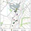
NGR NJ 4982 2700
NGR Description NJ 4982 2700 and NJ 4999 2716
Datum OSGB36 - NGR
Permalink http://canmore.org.uk/site/17200


- Council Aberdeenshire
- Parish Rhynie
- Former Region Grampian
- Former District Gordon
- Former County Aberdeenshire
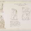
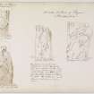
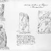
Rhynie 4, Aberdeenshire, Pictish symbol stone fragment
Measurements: H 1.58m (originally about 2.4m), W 0.69m (originally c1.8m)
Stone type:
Place of discovery: NJ 4982 2700
Present location: lost.
Evidence for discovery: recorded intact and standing at the Mains of Rhynie in the eighteenth century, the stone was broken up in 1803 for use as building stone. This largest fragment was broken up again for building purposes in1826.
Present condition:
Description
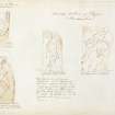
When complete, this slab was incised on one broad face with three symbols: the Pictish beast above a crescent and V-rod, with a mirror below.
Date: seventh century.
References: Logan 1829, 55; RCAHMS 2007, 121; Fraser 2008, no 43.4.
Desk-based information compiled by A Ritchie 2017
NJ42NE 36 4982 2700 and 4999 2716
(NJ 4982 2700) Sculptured Stone found here AD 1803 (NAT)
OS 25" map, Aberdeenshire, (1866-70)
(NJ 4999 2716) Part of Sculptured Stone found at South side of village AD 1803 (NAT)
OS 25" map, Aberdeenshire, (1866-70) and (1902)
A sculptured stone which originally stood at Mains of Rhynie seems to have been broken up in 1803 for use in building. When complete it was of granite, about 8 ft (2.4m) high and 6 ft (1.8m) broad. Logan shows it complete with elephant, crescent and mirror symbols on it. A fragment, also indicated by Logan, and illustrated in the Ordnance Survey Name Book (ONB, 1867) was built into the wall of a barn or stable having been taken from the former schoolhouse (though at what time is not clear). In 1826 the larger portion was completely broken up for building and by 1903 the smaller fragment had also disappeared.
J Logan 1929; Name Book 1867; J R Allen and J Anderson 1903.
Field Visit (5 October 1967)
No further information could be obtained regarding this symbol stone.
Visited by OS (NKB) 5 October 1967.
Note (15 January 1997)
This large Pictish stone was broken up in the 19th century and the present whereabouts of the fragments are not known.
Information from RCAHMS (JRS), 15 Jan 1997.
Reference (1997)
Class I symbol stone, Rhynie 4 (lost). A fragment showed an elephant a crescent and a mirror.
A Mack 1997.
Note (May 2017)
Discovering a Lost People
Modern day Rhynie is a rural village in central Aberdeenshire, surrounded by open countryside. It is a picturesque location, and deceptively modest, for archaeological evidence attests to many centuries of high status settlement in the area. Even the name Rhynie itself is regal, deriving from 'Rig' meaning King. Many Pictish stones have been found here, including the famous 'Rhynie Man', a 6ft high figure carrying an axe, found in a field in 1978.
So who were the Picts, and what were they doing at Rhynie? These are the very questions which are currently being investigated by The University of Aberdeen's Northern Picts project. The project aims to find the Picts in the landscape of Northern Scotland, and has had many notable successes in recent years. The Rhynie Environs Archaeology Project (REAP) is a key case study within the Northern Picts project. It is a collaborative endeavor between the Universities of Aberdeen, Chester and Glasgow and the local community artist collective Rhynie Woman.
Excavations in 2011 and 2012 revealed a series of fortified enclosures near to the the Craw Stane, a Class I Pictish symbol stone which still stands today. This is located at Barflat, northwest of the present day village and very close to where Rhynie Man was found in the 1970s. Early indications were that this was an important settlement. Further work revealed a series of concentric enclosures centred on a ring ditch and other possible timber structures, and in association with the Class I symbol stone. An interpretative reconstruction of the site has recently been completed and it is available to view online. You can access it by clicking on the link below.
Settlement evidence for this period is very rare, and the evidence for Pictish buildings which has been found at Rhynie is extremely important. Equally significant is the evidence for large-scale high status metalworking at the site, and a range of Continental imports which have been found here, indicating without doubt that Rhynie was an important power centre dating from the 4th to the 6th centuries AD. A contemporary cemetery has been found closer to the village.
Contextualising Rhynie / Moulds and Metal
The Rhynie Environs Archaeology Project is investigating the interaction between the high status site here and the wider landscape. The complex at Barflat is close to two small fortified sites at Cairnmore and Wheedlemont, and the great hillfort at Tap O'Noth [see previous Archaeology InSites feature under Age of Iron]. A 5th/6th century phase has been identified at Cairnmore and it is very likely that both Wheedlemont and Tap were in use at this time, but connections between these sites and Rhynie are still to be established. Understanding the links between these sites, and indeed if they are there at all, is key to understanding the development and control of the landscape of the Strathbogie area.
Rhynie has yielded a rich assemblage of high status material. One of the most iconic finds from the site is the axe shaped pin which was found in 2012. This pin, with its serpent design, resembles the axe which is carried by Rhynie Man, now in the reception area of Woodhill House, the headquarters of Aberdeenshire Council. The 2016 excavations revealed the best evidence yet for high status metalworking at Rhynie. Over 50 sherds of crucibles were found at the site, and clay moulds were uncovered in greater numbers than at any other known Pictish site. These moulds produced a range of different pins and brooches. There was even evidence for enameling. The finds from the 2016 season are currently undergoing conservation work, and although less visually striking than the finished products, they have the potential to tell us far more.
Dr Kirsty Owen - Archaeology and World Heritage Team
Excavation
NJ 4985 2702 A small test pit was opened around Rhynie No.3 (NJ42NE 22.02) measuring c.1 x 1 m and 0.3 m deep to expose the possible symbol carvings at the base of the human figure (Figure 2 and 3). The trench was opened by hand using a spade with plastic tools used in the immediate vicinity of the carved face on the southwest side of the stone to minimise any chance of damage. Soft brushes were used to remove any remaining soil around the face of the stone to allow recording of the stone face using digital recording techniques. These techniques included conventional digital SLR photography and photogrammetry.
The digital recording revealed new detail regarding the human figure and a possible symbol below their feet.
Archive: University of Aberdeen
Funder: University of Aberdeen and Historic Environment Scotland
Gordon Noble and James O’Driscoll - University of Aberdeen
(Source: DES Vol 20)

