
Rhynie, St Luag's Church


Burial Ground (Medieval), Church (18th Century), Sarcophagus (Medieval)
Site Name Rhynie, St Luag's Church
Classification Burial Ground (Medieval), Church (18th Century), Sarcophagus (Medieval)
Alternative Name(s) Kilrynie Parish Church; Rhynie, Old Parish Church
Canmore ID 17196
Site Number NJ42NE 32
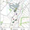
NGR NJ 49933 26490
Datum OSGB36 - NGR
Permalink http://canmore.org.uk/site/17196


- Council Aberdeenshire
- Parish Rhynie
- Former Region Grampian
- Former District Gordon
- Former County Aberdeenshire
St Luag's Church, medieval (site). A gabled and moulded Gothic recess containing a slab to Alexander Gordon, 1668, and an adjoining medieval stone coffin are the only survivals from this early foundation. Two early Pictish symbol stones (one with otter head) at the entrance were found in the kirkyard and may have come from the adjacent field which also produced the Rhynie Man (and Craw Stane; still there). Eighteenth-century graveslabs along kirkyard walls.
Taken from "Aberdeenshire: Donside and Strathbogie - An Illustrated Architectural Guide", by Ian Shepherd, 2006. Published by the Rutland Press http://www.rias.org.uk

NJ42NE 32.00 49933 26490
NJ42NE 32.01 Centred 49929 26471 Churchyard with Alex Gordon Tomb and adjoining Coffin
NJ42NE 32.02 49955 26512 Symbol Stones
(NJ 4993 2649) Church (NAT) (Site of) (AD 1700) (NAT)
OS 6" map, Aberdeenshire, 2nd ed., (1902)
For present parish church (NJ 4978 2716), see NJ42NE 114.
The parishes of Rhynie (formerly Kilrynie) and Essie were united in or about 1612; togethe, they formed a prebend of the Cathedral of Elgin. The church of Rhynie was dedicated to St Luag.
H Scott 1915-61.
The church of St Luag, Rhynie, was demolished in 1823 when the present church was erected. There are no remains of the old church. The ONB (1866) states that it was supposed to have been built about 1700 but references to a 1620 bell from the church now in the school, indicate an earlier structure.
Name Book 1866; F C Eeles and R W M Clouston 1960.
No remains of a church and no local knowledge of an earlier foundation indicated by the find of two Pictish symbol stones (See NJ42NE 30). Against the W wall of the graveyard, which is still used, there is a mediaeval grave and adjacent stone coffin.
Visited by OS (NKB) 3 October 1967.
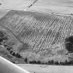
The kirkyard of Rhynie lies on an E-facing slope overlooking the Water of Bogie. It is rectangular in plan and enclosed by a coped rubble and mortar wall. The church has been removed, although a level area close to the centre may indicate its site. Several carved fragments from the church are built into the kirkyard dyke. The first, which lies 1.3m from the N end of the E wall, is a piece of red sandstone, measuring 0.3m by 0.16m, with a narrow roll-moulding along its longer edge. The second is a medieval tomb-recess built against the S end of the W wall. The recess measures 2.18m in width by 1.85m in height and 1.37m in depth and is incorporated into a reconstructed length of wall 2.94m long and 2.52m high. It has a pointed arch, and a roll-moulding around the opening. The keystone is, however, a replacement, probably of 19th-century date, for although it matches the mouldings in section, it does not continue their curve. Built into the back of the recess is the heraldic memorial slab of Alexander Gordon of Muirack, who died in 1668; it bears symbols of mortality and the sacred monogram IHS. Under the S jamb of the arch, the plinth upon which it has been rebuilt incorporates a fragment of moulding 0.48m in length by 0.31m in width and 0.12m in depth. Lying adjacent to the recess is a stone sarcophagus, which measures 1.93m in overall length by 0.45m in height and from 0.70m in breadth at the head to 0.52m at the foot. Internally it measures 1.74m in length and 0.33m in depth, tapering from 0.49m to 0.34m in breadth. The interior is shouldered with a shallower rounded recess for the head of the corpse 0.22m in depth. The curve of the head recess is expressed externally.
The graveyard is still in use, and numerous 18th-century stones have been removed and lined up against the W wall of the kirkyard to make way for modern burials.
Visited by RCAHMS (IF, PC), 27 June 1996.
Photogrammetric Survey (29 August 2014 - 31 August 2014)
NJ 49933 26490, NJ 4980 2715 and NJ 49749 26345 The ACCORD (Archaeology Community Co-production Of Research Data) Project was an Arts and Humanities Research Council (AHRC) funded research project led by the Digital Design Studio (Glasgow School of Art), with the University of Manchester, RCAHMS and Archaeology Scotland, which worked with 10 community groups across Scotland from October 2013 to March 2015. The project aimed to co-design and co-produce 3D digital data of heritage sites that are of significance to the community groups and which they wished to record.
The ACCORD team worked with the Rhynie Woman group based in Rhynie and Huntly, from 29–31 August 2014. Together we modelled and recorded a standing stone with Pictish symbols known as the ‘Craw Stane’, another Pictish symbol stone in the town square and two headstones in the Rhynie churchyard, one 18th-century and the other 19th- century in date. We used the techniques of photogrammetry and Reflectance Transformation Imaging.
Archive: ADS and National Record of the Historic Environment (NRHE)
Funder: Arts and Humanities Research Council
Stuart Jeffrey and Mhairi Maxwell – Glasgow School of Art
(Source: DES, Volume 16)

