
North Uist, Port Nan Long, General


Village (Period Unassigned)
Site Name North Uist, Port Nan Long, General
Classification Village (Period Unassigned)
Alternative Name(s) Newton Ferry
Canmore ID 171875
Site Number NF87NE 38
NGR NF 8952 7833
NGR Description Centred on NF 8952 7833
Datum OSGB36 - NGR
Permalink http://canmore.org.uk/site/171875


- Council Western Isles
- Parish North Uist
- Former Region Western Isles Islands Area
- Former District Western Isles
- Former County Inverness-shire
NF87NE 38 centred on 8952 7833
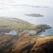
A township comprising six roofed buildings and one enclosure are depicted on the 1st edition of the OS 6-inch map (Inverness-shire, Hebrides, North Uist & Harris 1882, sheet xxxi). Eight roofed buildings and two unroofed buildings and six enclosures are recorded on the current edition of the OS 1:10000 map (1971). An oblique aerial photograph showing the village (CEU 1980), depicts 14 roofed buildings, two unroofed buildings and six enclosures.
Information from RCAHMS (ALD) 3 June 2004
Photographic Record (1906)
Photographs taken during a visit by the Churches Commission in July 1906.
The photographs are available in PA 71.

