
Following the launch of trove.scot in February 2025 we are now planning the retiral of some of our webservices. Canmore will be switched off on 24th June 2025. Information about the closure can be found on the HES website: Retiral of HES web services | Historic Environment Scotland
Monkland Canal, Glasgow


Canal (18th Century)
Site Name Monkland Canal, Glasgow
Classification Canal (18th Century)
Canmore ID 171663
Site Number NS66NE 59
NGR NS 6573 6615
NGR Description NS 6873 6500 to NS 6500 6598
Datum OSGB36 - NGR
Permalink http://canmore.org.uk/site/171663


- Council Glasgow, City Of
- Parish Glasgow (City Of Glasgow)
- Former Region Strathclyde
- Former District City Of Glasgow
- Former County Lanarkshire
NS66NE 59 From 6963 6500 to 6935 6500 and 6873 6500 to 6500 6598.
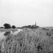
Near the SE corner of this map sheet the canal appears briefly as a small northerly loop and then reappears heading generally in a NW and then W direction. It is principally passing through open countryside, with a few coal pits in the vicinity, on both the 1st edition of the OS 6-inch map (Lanarkshire 1864, sheet vii) and on the 2nd edition of the OS 6-inch map (Lanarkshire 1899, sheets viiSW and viiNW).
Information from RCAHMS (MD) 24 January 2002.

