
Following the launch of trove.scot in February 2025 we are now planning the retiral of some of our webservices. Canmore will be switched off on 24th June 2025. Information about the closure can be found on the HES website: Retiral of HES web services | Historic Environment Scotland
Cairnbeg Hill


Cairn (Period Unassigned), Cairnfield (Period Unassigned), Ring Ditch House(S) (Prehistoric)
Site Name Cairnbeg Hill
Classification Cairn (Period Unassigned), Cairnfield (Period Unassigned), Ring Ditch House(S) (Prehistoric)
Canmore ID 17163
Site Number NJ41SW 4
NGR NJ 4004 1307
Datum OSGB36 - NGR
Permalink http://canmore.org.uk/site/17163


- Council Aberdeenshire
- Parish Towie
- Former Region Grampian
- Former District Gordon
- Former County Aberdeenshire
NJ41SW 4 4004 1307.
(Group centred: NJ 4004 1307) Tumuli (NR)
OS 6" map, Aberdeenshire, 2nd ed., (1902).
For enclosure at NJ 4015 1307, see NJ41SW 40.
See also NJ31SE 53.
On the summit of Cairnbeg Hill are several tumuli, consisting of heaps of small boulders. Some of them were opened several years before 1868 and found to contain human bones. They are thought to mark the site of a clan skirmish between the Gordons and Forbes.
Name Book 1868.
These 'tumuli' are similar to several stone clearance heaps around a ruined croft at NJ 4022 1310 and are probably associated with it, the hill appearing to have been cultivated fairly recently.
On the hill top about 30.0 metres to the S of the 'tumuli' is a vague, roughly circular bank, about 18.0 metres diameter, with a stony content onto which has been thrown a small quantity of stone clearance. Although in an excellent position for a cairn this is also probably associated with the ruined croft.
Visited by OS (R L) 29 August 1968.
The Ordnance Survey Name Book (ONB) describes several tumuli on this hill; bones were found when some were opened before 1868. The 'tumuli' are similar to several stone clearance heaps around a ruined croft. On the hill top (about 30m S of the 'tumuli') there is a vague roughly-circular bank with a stone content; stone clearance has been dumped inside it. Although an excellent position for a cairn, it is probably associated with the ruined croft. (The 'croft' noted by GRC is probably to be equated with NJ41SW 39).
Information from Mrs M Greig (Grampian Regional Council), 24 April 1995.
The summit of Cairnbeg Hill is an area of dry heathland at an altitude of 344m OD.
NMRS, MS/712/46.
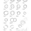
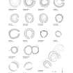
(Classification amended to Cairn, Small Cairns and Ring-Ditch Houses). A robbed burial-cairn, a scatter of small cairns and a group of ring-ditch houses is situated on the crest of the ridge known as Cairnbeg Hill. The robbed cairn, measuring 20m in diameter over a rim of cairn material 0.5m in height, is situated on the summit of the hill. Also occupying the summit area is the spread of small cairns, the largest measuring about 5m in diameter. The main concentration of cairns lies in a strip that runs along the crest of the ridge from a point 90m S of the large burial-cairn to a point 190m NE of the cairn. Further small cairns are scattered on the broken ground to the E of the large cairn, and a thin scatter towards the SW end of the ridge (NJ 398 127: NJ31SE 53) suggests that prior to agricultural improvements, particularly on the summit of the hill, the area occupied by the cairns was much more extensive.
Situated about 60m NNE of the large cairn are the remains of at least two, and probably three, ring-ditch houses set in a row. The central house (NJ 4018 1314) is the largest, measuring 8m in diameter over a ditch up to 2.6m in breadth and 0.2m in depth. The ditch is most clearly defined on the E and it is accompanied by a grass-grown external bank up to 5m in thickness and 0.2m in height, broken by a narrow entrance on the SE. The central tump measures about 4m in diameter.
The second ring-ditch house (NJ 4019 1316) is situated immediately to the NE. It measures about 7.8m in diameter over a ring-ditch up to 2.5m in breadth and 0.1m in depth. The central tump measures 5m from NW to SE by 4m transversely, and the ring-ditch is accompanied by a grass-grown external bank (3m in thickness and 0.1m in height) which is broken by an entrance on the SE.
The third probable ring-ditch house (NJ 4017 1313) lies immediately to the SW of the central house. It measures about 6m in diameter within a grass-grown bank up to 3m in thickness and 0.1m in height, and the entrance is on the SE. Although the bank is comparable to those of the other two houses, in this case no trace of an internal ring-ditch can be seen.
Visited by RCAHMS (JRS, PC), 10 September 1997.

