Pricing Change
New pricing for orders of material from this site will come into place shortly. Charges for supply of digital images, digitisation on demand, prints and licensing will be altered.
Upcoming Maintenance
Please be advised that this website will undergo scheduled maintenance on the following dates:
Thursday, 9 January: 11:00 AM - 3:00 PM
Thursday, 23 January: 11:00 AM - 3:00 PM
Thursday, 30 January: 11:00 AM - 3:00 PM
During these times, some functionality such as image purchasing may be temporarily unavailable. We apologise for any inconvenience this may cause.
New Morlich
Souterrain (Prehistoric)
Site Name New Morlich
Classification Souterrain (Prehistoric)
Canmore ID 17140
Site Number NJ41SW 1
NGR NJ 44438 14756
Datum OSGB36 - NGR
Permalink http://canmore.org.uk/site/17140
- Council Aberdeenshire
- Parish Towie
- Former Region Grampian
- Former District Gordon
- Former County Aberdeenshire
NJ41SW 1 4443 1474.
(NJ 4443 1474) Erd House (NR) (Remains of).
OS 6" map, Aberdeenshire, 2nd ed., (1902)
The entrance of this erd house has been mutilated by removing stones for building and is almost closed up with debris. It is said to be 4 1/2 feet wide and about 8 feet high and about 40 feet long, from the entrance in a NW direction.
Name Book 1866.
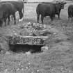
All that can be seen is a lintel stone, about 1.6m long, protruding from the turf on a SE facing slope. The farmer at New Morlich reports the souterrain collapsing about 1915 and the interior being filled with rubble.
Revised at 1/2500.
Visited by OS (R L) 25 August 1968.
This collapsed souterrain is situated on an SE-facing slope at an altitude of 280m OD.
[GRC ground photography and 1930's photographs from the collection of Dr John Johnstone cited].
NMRS, MS/712/46.
On the date of visit nothing was visible of this souterrain and its site lay in a field of potatoes. A farmworker related that the previously accessible part of the souterrain had been blocked-off and the site covered over with earth a good number of years ago.
Visited by RCAHMS (JRS, ARG), 1 October 1998.
Field Visit (29 July 1943)
This site was recorded as part of the RCAHMS Emergency Survey, undertaken by Angus Graham and Vere Gordon Childe during World War 2. The project archive has been catalogued during 2013-2014 and the material, which includes notebooks, manuscripts, typescripts, plans and photographs, is now available online.
Information from RCAHMS (GF Geddes) 4 December 2014.


