
Following the launch of trove.scot in February 2025 we are now planning the retiral of some of our webservices. Canmore will be switched off on 24th June 2025. Information about the closure can be found on the HES website: Retiral of HES web services | Historic Environment Scotland
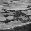
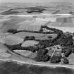
Mains Of Brotherton


Farmhouse (Period Unassigned), Farmstead (Period Unassigned)
Site Name Mains Of Brotherton
Classification Farmhouse (Period Unassigned), Farmstead (Period Unassigned)
Alternative Name(s) Brotherton Castle, Mains Farm; Lathallan School
Canmore ID 171156
Site Number NO76NE 51
NGR NO 7985 6785
Datum OSGB36 - NGR
Permalink http://canmore.org.uk/site/171156


- Council Aberdeenshire
- Parish Benholm
- Former Region Grampian
- Former District Kincardine And Deeside
- Former County Kincardineshire
NO76NE 51 7985 6785
For Lathallan School (Brotherton Castle) at NO 8027 6770 and associated buildings, see NO86NW 13.00.

