
Ensay, Ensay House


House (Period Unassigned)
Site Name Ensay, Ensay House
Classification House (Period Unassigned)
Alternative Name(s) Taigh Easaigh
Canmore ID 171094
Site Number NF98NE 22
NGR NF 98078 86508
Datum OSGB36 - NGR
Permalink http://canmore.org.uk/site/171094


- Council Western Isles
- Parish Harris
- Former Region Western Isles Islands Area
- Former District Western Isles
- Former County Inverness-shire
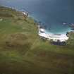
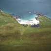
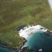
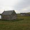
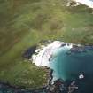
ENSAY (Easaigh - Sound of Harris) Historically belonging to the lairds of Harris, the sister isles of Ensay and Killegray are celebrated in visitors' descriptions for their rich arable pastures. Lying long and low among the myriad scattered islands, reefs and skerries of the Sound of Harris, each comprises about 500 acres. Ensay was the farm, occupied by the improving Campbells of Ensay, and then, from 1856, by Archibald Stewart of Luskentyre (Lord Dunmore's factor) and his descendants. The island has recently been bought by the owner of Killegray and is not permanently occupied. Rising up above the beach, Ensay House (today in separate ownership) dates from before 1805 (it appears in William Bald's map of this date). Remodelled in the mid-19th century, the former tacksman's house was described in the census of 1851 as "a gentleman's seat", and, by 1871, had 14 rooms with one or more windows. A visitor described the dining room walls as covered with"guns and rods, skulls and tusks...devoid of all ornament but the instruments and trophies of the chase ". The late medieval chapel to its east was restored as an Episcopal chapel in 1910. The round-arched doorway has a fine oak door carved by Robert Thompson of Kilburn, North Yorkshire, with a granite slab above inscribed in Gaelic. At the north end of Ensay, on the dunes above Manish Strand, recent excavations have revealed evidence of another 12 th century chapel. Other archaeological finds have included a "pair of scales made of brass, and a little hammer, both which were finely polished", discovered in a Viking grave.
Taken from "Western Seaboard: An Illustrated Architectural Guide", by Mary Miers, 2008. Published by the Rutland Press http://www.rias.org.uk


