
Newhailes, Flower Garden


Formal Garden (18th Century)
Site Name Newhailes, Flower Garden
Classification Formal Garden (18th Century)
Alternative Name(s) Newhailes House; Long Garden
Canmore ID 171084
Site Number NT37SW 168.09
NGR NT 32649 72533
Datum OSGB36 - NGR
Permalink http://canmore.org.uk/site/171084


- Council East Lothian
- Parish Inveresk (East Lothian)
- Former Region Lothian
- Former District East Lothian
- Former County Midlothian
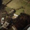
Located to the north-west of Newhailes House, the Flower Garden consists of two areas; the Long Garden running on a SW-NE axis between the west terrace and the Flower Garden to the north-west which is enclosed by brick walls. This area is significant as it is overlooked by the bedrooms of the house, and has been redesigned a number of times.
The Long Garden was formed between the straight wall along the south-east side of the Flower Garden and the west earth terrace, with the Icehouse and Fruit Store at the north-east end and a right-angled extension to the long straight wall at the south-east end, probably with a gate. While the majority of the straight wall has gone, two parts remain at either end and are significant:
• the north-east end of the straight wall, which extends beyond the limits of the Slip Garden, to contain the area on the north-west side of the Icehouse
• at the south-west end, a short length of the straight wall and the right-angled extension is continued on the opposite side of a gap as a c.6-7m length of 1.34m high arrow-topped wrought iron railing (matching that at the main gates) on top of a brick wall with a stone cope.
On the 1798 estate plan the Long Garden is shown as a lawn with trees along the north-west side, around 100 years later (ca. 1890) a photograph shows that the area has been laid out to an ornate geometric pattern.
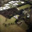
The Flower Garden was enclosed by brick walls, a segmental curved wall on the north-west, of which only the western part of the curved wall remains, a length of c.37m, all c.2.4m high and c.600mm wide, and a similar straight wall on the south-east side, of which only a c.35m length at the north-east end remains. The coping of both walls consists of bricks on edge (headers) with bricks angled at 45 degrees on one side, cut to fit the wall head, and still present on most of the wall. The curved wall has eight bulky stone buttresses on its convex outer face and comprises at least four different periods of construction, starting from the south end:
• 7m of stretcher bond, with 1.05m wide gate near end
• 11m with headers every 7th course
• 5m in a large brick, with a battered inner face, stretchers with only one header course
• 14m mixed headers and stretchers.
Within the area is a free-standing section of straight wall at approximately 45 degrees to the south-east wall, 13-14m long, broken off at the west end, entire at the east end, with a flat stone cope, stepped in plan 7m from the east end. This step relates to the base courses of the conservatory/greenhouse visible on the aforementioned 19th century photography, on the south face of the wall, c.3.5 x 7m, up to 500mm high with a stone cope remaining in parts.
Archaeological work carried out over a number of years in this area has furthered the understanding of the Flower Garden.
A geophysical survey was carried out in 1999 across the Flower Garden. A number of high-resistance anomalies were found which, in relation to an 18th-century plan of the garden, are consistent with paths, paved areas around a sundial and the glasshouse, as well as the greenhouse foundations, and a boiler to the rear of the glasshouse.
Excavation work in 2001 attempted to understand the nature and phases of the garden, targeting a number of the features identified from the geophysical survey. The anomaly to the rear of the glasshouse was excavated and found to be a furnace stoke hole. This retained a cast-iron surround with part of its cast-iron door also remaining in situ, and part found loose. A grate within the stoke hole permitted ash to fall into an ash box below. The intra-mural flue rose into the wall just beyond the rear of the firebox.
The firebox was located within a sunken brick-lined pit, about 1m deep. This structure was almost square in plan (1.24m wide by 1.20m), with a further smaller square projection from its N wall of 0.90m by 0.90m. The pit floor was formed of bricks lain flat, this continued into the ash pit below the firebox.
The mortared brickwork of the walls survives in excellent condition up to its upper part, which has been largely robbed of its coping course. Most of one coping survives and there are impressions of others. The surviving stone, at the SE corner of the pit, is neatly cut and displays a well-tooled face of distinctively Georgian character, its upper surface lies at exactly 1.2m above the floor of the pit. Significantly this block retains a wrought iron hinge pintle, counter-sunk and fixed by lead into a seating in its upper surface. A corresponding hinge band was found loose within the pit fill along with a number of perished sections of pine planking. These demonstrate that the pit had been covered in a wooden hatch that had opened upwards against the rear of the heated wall when the fire was being stoked. There may also have been an opposing hatch covering the N projection of the pit.
The purpose of the N projection became clear upon excavation; within remained in situ a pile of coal with an attendant stoke shovel. This hand shovel neatly fitted both the stoke hole and ash pit.
Just beyond the N side of the projection part of a compacted ash surface or path was located (but not defined). This lay level with the surviving brickwork of the pit wall.
A series of test trenches were also excavated within the flower/long garden and slip garden in order to investigate the survival of the former layouts of the gardens.
The remains of an in-situ gate were recorded in the landscape survey for Newhailes, directly in line with the north face of the house, to the W of the West Wing. Two trenches were opened next to it and it appears that the cinder and ash layers uncovered were laid with respect to the gate and step, and it would be reasonable to assume that this was the original path from the house to the Long Garden. Evidence of a fence line, probably contemporary to the fence separating the Flower Garden from the Long Garden, was also recovered suggesting that the path is at the latest 19th century in origin.
A trench was excavated across the width of the Long Garden in order to ascertain the nature of any remnant surfaces within the Long Garden. This also aimed to define the boundary between the Long and Flower Gardens, as well as the survival of any bed and path arrangements. The evidence for surfaces within the Long Garden is generally inconclusive, as the differences between layers were not greatly marked. However the boundary was identified; this was originally built from brick and of similar character to the curving wall around the flower garden. At some point an iron fence, of which only the two end posts survive above ground, had superseded it.
Two trenches were placed to investigate the survival of path/bed arrangements within the flower garden. One (Tr30) was aligned at approx 45° to the main axis of the garden (i.e. not running along a path but cutting across it), whilst the other (Tr31) was placed coming out from the curved boundary wall.
Within Trench 31 a series of features running parallel to the wall were located 10-15 cm below current ground. These features appear to represent an outer bed about 3m wide butting against the boundary wall to the south and a path 90cm wide comprised of compacted brick red gravel to the north, with further beds to the north of the path.
In Trench 30 a well-defined path was located 10cm below current ground level, the path was constructed from a base of compacted red blaze with a covering 4-5cm of small pea gravel. To the west and east of this path appeared to be bedding. Within the east edge of the path was a sandstone rectangular ring feature; almost certainly the base of a water standpipe and fed from a 1 inch copper pipe, running about 35 cm below ground.
The excavations demonstrated that the evidence for the Flower Garden layout is quite intact and generally buried to a very shallow depth.
In 2007 the wall forming the rear of the conservatory/glasshouse was surveyed and recorded following a partial collapse. This work enabled the flue system in the east and west halves of the wall to be recorded and better understood, finding that each flue had been plastered internally and uncovering a mechanism for controlling and regulating the heat flow. The heated wall, built of handmade brick in the 18th century, showed a sophistication of design and use, for both an external heated wall and an internal greenhouse wall, with the furnace uncovered during the 2001 excavation providing the heat for the flues. Following this, the western wall was rebuilt to elevation plans produced during the building recording.
(Information from the National Trust for Scotland January 2013)
NT37SW 168.09 3273 7246
NT 3273 7246 A geophysical survey was carried out in an area to the E of Newhailes House, previously the site of a formal garden. A number of high-resistance anomalies were found which, in relation to an 18th-century plan of the garden, are consistent with paths, paved areas around a sundial and a conservatory, hot house foundations, and the base of the conservatory ?boiler house.
The gardens included some 80 acres of parkland laid out in the 18th century as a designed landscape. Much of this has since reverted to nature. The formal flower garden was designed by John Hay in 1818, but a photo taken in around 1909 shows that the planned layout was not fully carried out, or it was changed, as the layout of paths and flower beds is different. The rectangular pond had been infilled in and used as a car park.
Sponsors: National Trust for Scotland, Edinburgh Archaeological Field Society.
H M D Jones 1999
NT 326 725 Previous archaeological work has involved extensive evaluations of the designed landscape and villa (DES 2001, 33-4).
Watching briefs and evaluations were conducted in 2002 on various parts of the 18th-century and later designed landscape, providing useful additional information on the paths, roads and curling pond.
Archive to be deposited in the NMRS.
Sponsor: NTS.
A Daly (NTS) 2002
NT 325 727 The NTS volunteer Thistle Camp in June 2002 involved a number of problem-oriented evaluations and investigative exercises focusing on specific structures and areas within the Newhailes policies. A principal focus of the work was the Shell House and its immediate surroundings, where the original evaluation and recording completed in 2000/2001 was considerably extended. Substantial works were also undertaken at the Tea House, at the downstream end of the Newhailes water gardens - this included clearance, excavation, building recording and architectural analysis. A further small architectural recording and evaluation exercise was undertaken at the entrance gate piers at the SW end of Lady's Walk.
Another major aspect of the Thistle Camp programme was the investigation of the network of historic paths that formerly ran through the woodland shelter belt, particularly in the area of the water gardens. A series of evaluation trenches were located at key points along the ha-ha, to further investigate its phasing and details of its construction. Two topographic survey exercises were also carried out, one in the cabinet garden and the other in the area of the Shell House.
D Connolly (Addyman Associates) 2002
Earth Resistance Survey (1999)
NT 3273 7246 A geophysical survey was carried out in an area to the E of Newhailes House, previously the site of a formal garden. A number of high-resistance anomalies were found which, in relation to an 18th-century plan of the garden, are consistent with paths, paved areas around a sundial and a conservatory, hot house foundations, and the base of the conservatory boiler house.
The gardens included some 80 acres of parkland laid out in the 18th century as a designed landscape. Much of this has since reverted to nature. The formal flower garden was designed by John Hay in 1818, but a photo taken in around 1909 shows that the planned layout was not fully carried out, or it was changed, as the layout of paths and flower beds is different. The rectangular pond had been infilled in and used as a car park.
Sponsors: National Trust for Scotland, Edinburgh Archaeological Field Society.
H M D Jones 1999
Archaeological Evaluation (June 2002)
NT 325 727 The NTS volunteer Thistle Camp in June 2002 involved a number of problem-oriented evaluations and investigative exercises focusing on specific structures and areas within the Newhailes policies. A principal focus of the work was the Shell House and its immediate surroundings, where the original evaluation and recording completed in 2000/2001 was considerably extended. Substantial works were also undertaken at the Tea House, at the downstream end of the Newhailes water gardens - this included clearance, excavation, building recording and architectural analysis. A further small architectural recording and evaluation exercise was undertaken at the entrance gate piers at the SW end of Lady's Walk.
Another major aspect of the Thistle Camp programme was the investigation of the network of historic paths that formerly ran through the woodland shelter belt, particularly in the area of the water gardens. A series of evaluation trenches were located at key points along the ha-ha, to further investigate its phasing and details of its construction. Two topographic survey exercises were also carried out, one in the cabinet garden and the other in the area of the Shell House.
D Connolly (Addyman Associates) 2002
Watching Brief (2002)
NT 326 725 Previous archaeological work has involved extensive evaluations of the designed landscape and villa (DES 2001, 33-4).
Watching briefs and evaluations were conducted in 2002 on various parts of the 18th-century and later designed landscape, providing useful additional information on the paths, roads and curling pond.
Archive to be deposited in the NMRS.
Sponsor: NTS.
A Daly (NTS) 2002
Excavation (15 September 2014 - 22 September 2014)
NT 32649 72533 A community volunteer excavation was undertaken, 15–22 September 2014, in order to assess the level of preservation of the remains of the formal flower garden design from the 19th and 20th centuries. A series of red and black ash pathways were uncovered, along with pipes running to the nearby glasshouse site and a large amount of garden terracotta type pottery.
Archive: RCAHMS (intended)
Funder: The National Trust for Scotland
Daniel Rhodes – The National Trust for Scotland
(Source: DES)
Excavation (8 December 2017)
Addyman Archaeology undertook an historic building survey at the Flower Garden, Newhailes House and Estate, in December 2017. The works concerned the exposure, cleaning and recording of the wall footing of a curved boundary wall to a mid to late 18th-century formal garden. A drawn, written and photographic record was produced for the wall footing and its immediate context. A sherd of green-glazed pottery was also recovered.
Information from OASIS ID: addymana1-304511 (T Skinner) 2017

