
Clova, Kildrummy


Cup And Ring Marked Stone(S) (Prehistoric), Cup Marked Stone(S) (Prehistoric), Souterrain(S) (Prehistoric), Ladle (Stone)(Period Unassigned), Quern(S) (Period Unassigned)
Site Name Clova, Kildrummy
Classification Cup And Ring Marked Stone(S) (Prehistoric), Cup Marked Stone(S) (Prehistoric), Souterrain(S) (Prehistoric), Ladle (Stone)(Period Unassigned), Quern(S) (Period Unassigned)
Alternative Name(s) Muirs Of Kildrummy; Muirs Of Clova; Moor Of Clava
Canmore ID 17079
Site Number NJ41NE 1
NGR NJ 46000 19600
Datum OSGB36 - NGR
Permalink http://canmore.org.uk/site/17079


- Council Aberdeenshire
- Parish Kildrummy
- Former Region Grampian
- Former District Gordon
- Former County Aberdeenshire
NJ41NE 1.00 460 196
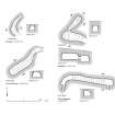
NJ41NE 1.01 NJ 4609 1960 Souterrain; Cup-and-Ring markings; Cup-markings
NJ41NE 1.02 NJ 4610 1927 Souterrain; Cupmarkings
Formerly also entered as NJ42SE 16.
(Group centred NJ 460 193 Eleven shown) Erd House (NR) (Site of)
(NJ 4609 1960 and NJ 4610 1927) Erd House (NR)
(NJ 4592 1945) Querns found (NAT)
(NJ 4577 1896) Quern found AD 1841 (NAT)
(NJ 4589 1898 and NJ 4547 1887) Querns found AD. 1847 (NAT)
(NJ 4573 1898) Stone Ladle found AD. 1826 (NAT)
OS 6" map, Aberdeenshire, 1st ed., (1869)
Two earth-houses, amongst a number of them, 'in the moor of Clava', on an eastern slope were cleared out by H G Lumsden, in 1875. The ground belonged to C P Gordon of Wardhouse and Kildrummy. The northern-most contained ashes and charred wood, animal bones, broken querns and a broken stone lamp. No flint implements were found. The earth-house had been mutilated by removal of stones in 1821 by a neighbouring farmer. The other earth-house, of which Lumsden gives a plan and sections (1878) contained charcoal, bones, horses' teeth, and jaws of dogs. Two wall-boulders were cup-marked.
H G Lumsden 1878.
Between 40 and 50 earth-houses are said to have been found in the parishes of Auchindoir and Kildrummy, 'over a space a mile or two in diameter', prior to 1822. The area was once forest but is now a dry moor and the structures were either found in ploughing or by Stuart observing an earth work enclosure with which they were generally associated.
These enclosures were 10 - 15 paces square and were dug a foot or two deep with the earth thrown outwards.
They usually adjoined the entrance to the earth house which was formed by two boulders, circa 18 inches apart, with an oblique descent of 5 -6 feet into a chamber 30ft long, 5-6 feet high and 8-9 feet wide. The chamber floor was flat and the walling of dry-stone with capping slabs only a few inches below the surface. No associated finds were made but wood ashes and charcoal were often found at the far end of the chamber where a small aperture usually formed a flue.
Simpson (W D Simpson 1934) says that the village was horse-shoe-shaped, with southern exposure and was occupied from about 100BC to 400 AD, but Mitchell (H Mitchell 1921) states that these earth houses were known to have been inhabited within the last two hundred years and had fireplaces at their ends.
Simpson adds that of the two earth houses remaining in
1934 one was 80 feet long. The Name Book (1867) refers to three extant passages and a number of crop covered sites, some found 'forty years ago'.
A great number of querns had been found in this area, three being sites and described as found in 1841 and 1847 by Alexander Crow of Blackbaulk in ploughing, who found a large stone 'Ladle' in 1826 as well as a number of the earth houses. The 'ladle' may be the stone cup from Wester Clova Farm, in King's College Museum, Aberdeen (R W Reid 1912) In the National Museum of Antiquities of Scotland (NMAS) is a holed stone from an earth house at Kildrummy presented by Miss Gordon in 1871 (PSAS 1873)
J Stuart 1822; Name Book 1867; Proc Soc Antiq Scot 1872; R W Reid 1912; H Mitchell 1921; W D Simpson 1934.
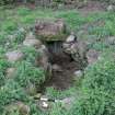
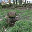
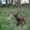
Two souterrains are preserved in good condition but there is no trace and no local knowledge of others in the area, nor of any associated enclosures.
Re-surveyed at 1/2500.
Visited by OS (N K B) 20 September 1968.
(NJ 4576 1895). Another quern was found on the 15th May 1974, during ploughing, by Mr Bruce, Honeybarrel. It is now beside the 'museum' in the care of Kildrummy Castle Gardens Trust. It is slightly damaged.
Information contained in letter and sketch plan from Mrs J P Smith to OS 3 June 1974.
(GRC/AAS sites NJ41NE 1 and NJ41NE 44 -60; name cited as Muirs of Kildrummy).
TISSFC, 8 (1912-18), 30-1 reference noted.
Air photographs: AAS/81/3/S3/3, flown 22 January 1981.
NMRS, MS/712/45.
(Noted by GRC/AAS as NJ42SE 13 at cited location NJ 462 202). This discovery was initially mis-attributed to the Muirs of Kildrummy (NJ 46 19).
NMRS, MS/712/48.
Little information is available about the forty to fifty souterrains said to have been discovered within a relatively restricted area in the N part of Kildrummy parish. A remarkable concentration of thirteen souterrains lies within the roughly triangular area of cultivated ground between the steadings of Wester Clova (NJ41NE 55) on the W, Blackbaulk (NJ41NE 57) on the S, and Backstone (NJ41NE 75) on the NE, and the discovery of querns at five other locations may indicate the sites of additional examples. Two of these souterrains (NJ41NE 1.01 & 1.02) are still open, and it is quite likely that some of the reported sites survive beneath the ploughed fields. The recorded distribution appears to display a distinct pattern, whereby four individual or small groups of souterrains are regularly spaced along the 230m OD contour separated by distances of between 200m and 250m. To some extent this pattern breaks down towards the southern part of the distribution, where the sites of known souterrains and the findspots of querns are clustered more closely.
Information from RCAHMS (JRS), 2 March 1998.
Scheduled as Muirs of Kildrummy, souterrains 230m W of and 350m SSW of...
Information from Historic Scotland, scheduling document dated 2 December 2003.
Field Visit (26 July 1943)
This site was recorded as part of the RCAHMS Emergency Survey, undertaken by Angus Graham and Vere Gordon Childe during World War 2. The project archive has been catalogued during 2013-2014 and the material, which includes notebooks, manuscripts, typescripts, plans and photographs, is now available online.
Information from RCAHMS (GF Geddes) 4 December 2014.
Field Visit (1 October 2008 - 30 November 2008)
(NJ 46068 19086) Field survey recorded that five large, flat stones had been dumped in the corner of the existing field. The stones each measured
approximately 2m by 2.5m and 0.2m thick. A number of smaller stones were scattered amongst them. The stones may originally have belonged to a souterrain within the field.
(NJ 46055 19075) Field survey recorded a scatter of large stones along the field edge. The largest stones measure 1m by 1.5m, the majority are under 0.8m in length. The stones may originally have belonged to a souterrain
within the field.
(NJ 45580 19210) Field survey recorded a spread of large and medium sized stones along the edge of the field. Whilst large flat stones were absent, unlike at sites (7) and (8), it is considered possible that the stones may
originally have belonged to a souterrain within the field. The Ordnance Survey 1st Edition map (1870) depicts the site of a souterrain at this location.
Information from OASIS ID: cfaarcha1-423299 (T Neighbour) 2008
Note (11 May 2019)
Date Fieldwork Started: 11/05/2019
Location Notes: This record is a grouped ID that includes the 2 definite and 2 possible cup marked and cup and ring marked stones in the two Clova Kildrummy souterrians. These panels have been recorded under Clova Kildrummy 1 and 2 (ScRAP 989, Canmore 160272) and Clova Kildrumy 3 and 4 (ScRAP 771, Canmore 160271).

Aberdeenshire Historic Environment Record
Aberdeenshire Historic Environment Record
Aberdeenshire Historic Environment Record
Aberdeenshire Historic Environment Record
Aberdeenshire Historic Environment Record
Aberdeenshire Historic Environment Record
Aberdeenshire Historic Environment Record
Aberdeenshire Historic Environment Record
Aberdeenshire Historic Environment Record
Aberdeenshire Historic Environment Record
Aberdeenshire Historic Environment Record
Aberdeenshire Historic Environment Record
Aberdeenshire Historic Environment Record
Aberdeenshire Historic Environment Record
Aberdeenshire Historic Environment Record
Aberdeenshire Historic Environment Record
Aberdeenshire Historic Environment Record
Aberdeenshire Historic Environment Record
