
Pricing Change
New pricing for orders of material from this site will come into place shortly. Charges for supply of digital images, digitisation on demand, prints and licensing will be altered.
East Kilbride, General


Burgh (Medieval), Town (20th Century)
Site Name East Kilbride, General
Classification Burgh (Medieval), Town (20th Century)
Canmore ID 170786
Site Number NS65SW 67
NGR NS 6290 5405
NGR Description Centred NS 6290 5405
Datum OSGB36 - NGR
Permalink http://canmore.org.uk/site/170786


- Council South Lanarkshire
- Parish East Kilbride (South Lanarkshire)
- Former Region Strathclyde
- Former District East Kilbride
- Former County Lanarkshire
New Town designated 1947. Granted burgh status May 1963.
The town's name derives from St Bryde (or Brigit), and the 'Kil' which comes from the Gaelic 'cil' - church or burying place. St Bryde is said to have been born in Scotland in AD 451 and to have died 74 years later at Abernethy.
The Official Guide to East Kilbride
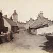
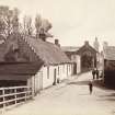
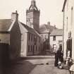
Photographic Record (1885)
Photographs in album titled 'Views in Busby, East-Kilbride, Carmunnock, Mearns, Eaglesham, and their vicinity 1885'

