
Scalan, North Steading


Graffiti(S) (19th Century) - (20th Century), Threshing Barn (19th Century), Threshing Machine (19th Century), Watermill (19th Century)
Site Name Scalan, North Steading
Classification Graffiti(S) (19th Century) - (20th Century), Threshing Barn (19th Century), Threshing Machine (19th Century), Watermill (19th Century)
Alternative Name(s) Braes Of Glenlivet
Canmore ID 170726
Site Number NJ21NW 21.03
NGR NJ 24595 19510
Datum OSGB36 - NGR
Permalink http://canmore.org.uk/site/170726


First 100 images shown. See the Collections panel (below) for a link to all digital images.
- Council Moray
- Parish Inveravon
- Former Region Grampian
- Former District Moray
- Former County Banffshire
The north steading appears to be of early twentieth-century date, but may incorporate earlier remains.
It is a two-storeyed structure, L-plan structure. The east wing housed a stable, while the main, western portion of the building once had two cart sheds at its north end, together with mill machinery located in the western part of the building. The wheel was housed in a lean-to structure. In the 1970s, the millwheel and associated machinery remained intact, and was used to power a battery at nearby Scalan Cottage.
Text prepared by RCAHMS as part of the Accessing Scotland's Past project
Field Visit (August 2014)
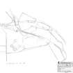
Scalan, North Steading and Threshing Mill (see drawings SC1483788, SC 483797 and SC1483799)
This two-storeyed, rubble-built, slate-roofed, L-plan steading range dates from the late 19th/ early 20th century. The building is not shown on the 1st edition Ordnance Survey 6-inch map (Banffshire, 1872 (surveyed 1869), Sheet XLI). It is, however, depicted as an L-shaped, roofed building with outshot (waterwheel house) on the 2nd edition Ordnance Survey 6-inch map (Banffshire, 1904 (surveyed 1900), Sheet XLI). This suggests that the building dates from the period 1870-1900.
The west range of the North Mill contains: a threshing barn with threshing area and machinery on two floors with partition walls of split logs in plank and lathe style subdivided into a corn barn with wooden floor on earth beneath, access through door at south end to upper floor accessing the threshing machine at upper level; un-thrashed corn storage area; straw barn with opposing doors in west and east elevations, earthen floor, stone slab on threshold, half rubble and wood party wall to cart shed at north end butted up against west and east internal walls, and double cart shed at the north end of the range (east door of shed now partially blocked and with later door inserted, manger along east interior wall) with hayloft above (see DP190774).
The east range houses a four stall stables with the original feed troughs (or mangers, six in total surviving), horse feed kist or chest and rack for tack storage. The interior walls are plastered (east and west walls), earth floor with all stalls made of timber. The upper part of the east gable wall wood from wall head to gable point is of wooden plank construction, cement consolidation at wallhead. There are tuskers visible on the exterior of the east wall suggesting that a range was planned but never built (see DP190775).
The cast iron waterwheel (3.7m or 12 feet in diameter) is housed in a lean-to structure with a mono-pitch roof continuous to the roof line of the west range. A re-used van door allows ingress on the north wall. The waterwheel is a low-mid breastshot 'start and awe' waterwheel. The term 'start' refers to the piece of wood secured in the rim and projecting from it, onto which the 'awe' or the wooden float or paddle was attached (at a 40 -45 degree angle). The lade is of timber and the launder is constructed to give a tight fit as the water was guided to the wheel. It worked on the velocity of the water as it hit the wheel. This launder fed the water directly onto 3 or 4 paddles at the mid-breast point of the wheel, moving the waterwheel in a clockwise direction.
The waterwheels in the North Steading Mill and the South Steading Mill are of the same diameters and type (but slightly different castings) but the starts supporting the floats or paddles are longer on the North Mill. This suggests that more power was needed to operate the threshing machine in this building than in the South Steading Mill.
The gear cupboard which drove the threshing machine is against west wall and was directly driven by the waterwheel. There is graffiti in the gear cupboard with a date range of 1912-1929, including "13th April 1927 Bought Plow from Sillars and Co Huntly for £6:2... and "1927 The disasterous harvest of 1927 will not be forgot[t]en in The memory of any of us".
Visited by RCAHMS (MMD), 26th August 2014.
Field Visit (7 June 2016 - 10 June 2016)
As part of a graffiti art pilot project undertaken by HES in 2016, a range of graffiti was recorded within the interior of the threshing mill and the adjoining stable in the North Steading at Scalan. The aim of the project was to record and transcribe the graffiti that was known to have been written on many of the timber fittings, including doors, plank and lathe wall linings, the thrashing machine and some of the rafters. The graffiti ranges from pencil-written local histories and names and dates (mainly between 1874 to around 1955, but with a few more recent dates) to drawings of people and animals. There are also a limited number of chalk and crayon illustrations. The graffiti provides evidence of ‘everyday’ lives on the farm. Much of the graffiti is closely-spaced and there is also an amount of over-writing. Given the density of the graffiti and the amount of over-writing, this description aims to group the graffiti into a range of general categories, which through further research can be expanded.
Most of the graffiti in the mill is concerned with the day-to-day running of the farm and the information it contains ranges from such things as the costs and quantities of materials required by the farm, to the number of timber posts and the length of wire required for fencing. The yields of different produce from the farm are carefully detailed and in some cases the writers have used the vertical planking on the doors in order to add up quantities and establish costs -- in the same way a columnar notebook would be used. On a personal level the graffiti charts people’s relationships and describes who performed what roles on the farm. In addition, there is evidence relating to global events and how they impacted on the farm, including people going to and returning from war. Specific social occasions are also documented, including trysts and marriages. On one of the stable stalls there are details of a cricket match held between teams representing Tomintoul and Glenlivet. There is a large quantity of drawings of animals, including sheep, cattle, wild cats, otters and weasels.
Visited by HES, Survey and Recording (AGCH, ZB) 7-10 June 2016.
Project
Recording Scotland's graffiti project was designed to review the range of historic and contemporary graffiti art across Scotland. It involved desk-based assessment and fieldwork at a number of example sites, to consider recording methodologies and dissemination practices.
Between 2016 and 2017, phase 1 of the project aimed to:
Aim 1: review a range of historic and contemporary graffiti art from across Scotland, already present in Canmore.
Aim2: undertake a research review of previous approaches to recording graffiti art in Canmore and other HERs, review and develop the current Thesaurus terms.
Aim 3: test and develop a range of recording methods within the following programmes or projects: Discovering the Clyde programme (1223), Scotland’s Urban Past (1222), Architecture and Industry projects, such as Urban Recording Projects (1028), Area Photographic Survey (311) and the Tomintoul and Glenlivet Landscape Partnership (1167).
Aim 4: the following test sites will be considered for research into the range of historic and contemporary graffiti. They will be analysed to demonstrate the different ages, contexts, styles and survivals of historic and contemporary graffiti: Polphail village (Canmore ID 299112), Scalan farmstead (170726), Cowcaddens Subway Station (243099), Croick Parish Church (12503), Dalbeattie Armament Depot (76279) and Dumbarton Rock (43376).
Aim 5: to research the potential for social media to play a role in crowd-sourcing information and archiving Scotland’s graffiti art.
In 2017-2019, phase 2 of the project aimed to:
Aim 1: To enhance the NRHE to the point at which it can be said to adequately represent the broad range of historic and modern graffiti that is evident throughout Scotland, and to explore ways by which that information can best be disseminated.
Aim 2: To develop guidelines that will convey the HES approach to researching and recording graffiti.
Aim 3: To write a specification for a book on Scotland’s graffiti.
Aim 4: To develop external partnerships to explore further ways to record graffiti and to identify and explore potential funding streams to enable further knowledge exchange and research.
The project was managed by Dr Alex Hale, with contributions from staff across Herirtage and Commercial and Tourism directorates.

