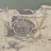
Accessibility

Font Size

100% 150% 200%

Background Colour

Default Contrast
Close Reset

Ness Of Brodgar

Cairn (Period Unassigned)(Possible)

Site Name Ness Of Brodgar

Classification Cairn (Period Unassigned)(Possible)

Canmore ID 1702

Site Number HY21SE 15

NGR HY 2941 1328

Datum OSGB36 - NGR

Permalink http://canmore.org.uk/site/1702

Ordnance Survey licence number AC0000807262. All rights reserved.
Canmore Disclaimer. © Bluesky International Limited 2025. Public Sector Viewing Terms

Toggle Aerial | View on large map

Digital Images

Oblique aerial view.
Oblique aerial view.Oblique aerial view.Oblique aerial view of the Ring of Brodgar, henge and stone circle, taken from the W.  Also visible are cairns and the 'Comet Stone'Ness Of Brodgar, HY21SE 15, Ordnance Survey index card, RectoOblique aerial view.Aerial view of Orkney, Ring of Brodgar, henge and stone circle, taken from the NW.   Also visible are   cairns and the 'Comet Stone'.Oblique aerial view centred on the Ring of Brodgar with the cairns adjacent, taken from the NW.Oblique aerial view.Aerial view of Orkney, Ring of Brodgar, henge and stone circle, taken from the N.   Also visible are   cairns and the 'Comet Stone'.Oblique aerial view centred on the Ring of Brodgar stone circle and henge, taken from the ENE.Oblique aerial view centred on the Ring of Brodgar with the cairns adjacent, taken from the SW.Aerial view of the Ring of Brodgar, henge and stone circle, taken from the SW.  Also visible are some of the surrounding cairns.Aerial view of Orkney, Ring of Brodgar, henge and stone circle, taken from the SE.  Also visible are cairns and the 'Comet Stone'.Oblique aerial view centred on the Ring of Brodgar with the cairns adjacent, taken from the SW.Oblique aerial view.Oblique aerial view.Oblique aerial view.Oblique aerial view.Ness Of Brodgar, HY21SE 15, Ordnance Survey index card, Recto

Administrative Areas

  • Council Orkney Islands
  • Parish Stenness
  • Former Region Orkney Islands Area
  • Former District Orkney
  • Former County Orkney

Archaeology Notes

HY21SE 15 2941 1328.

(HY 2941 1328) Tumulus (NR)

OS 6" map, Orkney, 2nd ed., (1903).

A large flat-topped mound, but whether artificial or not cannot be ascertained without excavation.

RCAHMS 1946.

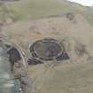
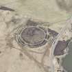
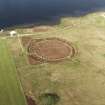
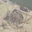
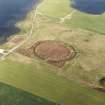
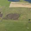
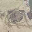
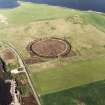
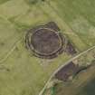
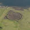
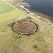
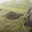
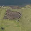
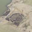
This probable cairn, an apparently artificial, grass-covered mound of earth and stones, measures 18.0m. in diameter and 1.8m. high. There is a shallow central depression in its top.

Resurveyed at 1.2500.

Visited by OS (RB) 24 April 1966.

Activities

Field Visit (1 May 1994)

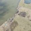
This large bowl-shaped mound measures 20.7m by 18.11m and 1.8m in height. It is in a prominent position next to the henge. It was noted as being in poor condition.

Information from the Orkney Barrows Project (JD), 1994

References

MyCanmore Image Contributions


Contribute an Image

MyCanmore Text Contributions