
West Lindsaylands


Pit Defined Cursus (Neolithic), Pit Enclosure (Prehistoric)(Possible)
Site Name West Lindsaylands
Classification Pit Defined Cursus (Neolithic), Pit Enclosure (Prehistoric)(Possible)
Canmore ID 169737
Site Number NT03NW 125
NGR NT 01660 36570
NGR Description Centred NT 01660 36570
Datum OSGB36 - NGR
Permalink http://canmore.org.uk/site/169737


- Council South Lanarkshire
- Parish Biggar
- Former Region Strathclyde
- Former District Clydesdale
- Former County Lanarkshire
NT03NW 125 centred 01660 36570
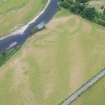
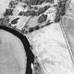
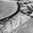
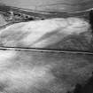
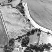
What may be the cropmarks of a pit-defined cursus lie on a terrace above the River Clyde some 450m to the SW of West Lindsaylands farm. It is defined by two rows of pits set parallel about 17m apart, which extend for a distance of at least 70m from ENE to WSW. Although no terminals can be identified with any certainty, a row of three pits appears to form a right-angled corner with the ENE end of the SSE row, suggesting a square-ended terminal at this point. To the WSW the cursus cannot have continued for more than a further 30m at which point the ground drops sharply to the river.
It is plotted as a cursus monument on a distribution map of Neolithic monuments covering southern Scotland (RCAHMS 1997, 115, fig. 110).
Information from RCAHMS (ARG), 7 April 1998.

