
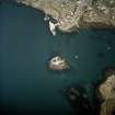
Barra, Castlebay, General


Town (Period Unassigned)
Site Name Barra, Castlebay, General
Classification Town (Period Unassigned)
Alternative Name(s) Bagh A' Chaisteil
Canmore ID 169694
Site Number NL69NE 64
NGR NL 6656 9828
NGR Description Centred NL 6656 9828
Datum OSGB36 - NGR
Permalink http://canmore.org.uk/site/169694


- Council Western Isles
- Parish Barra
- Former Region Western Isles Islands Area
- Former District Western Isles
- Former County Inverness-shire
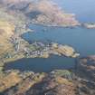
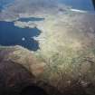
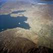
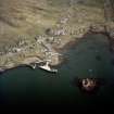
Barra's principal settlement lolls peacefully round the rocky fringes of the bay. At its core, the 'half-dozen good and well-placed buildings, Roman Catholic Church [and] few neat slateroofed houses belonging to successful tradesmen ...' observed in 1917 are still visible, although the village's character today as a Cal. Mac. ferry port bears little resemblance to the stirring scenes of a century ago. Castlebay became the 'herring metropolis' of the Hebrides, the key to Barra's relative prosperity at the turn of the 19th century. During the summer months, the bay was thick with tawny-sailed fishing boats, the 24 piers cluttered with curing stations and busy with the activities of an 'army of fishermen, gutters, coopers, curers and foreign buyers'.
Gen. MacNeil's 'intention to erect 'a fishing village consisting of 70 small houses or thereabouts' (1825) amounted to little more than a scattering of blackhouses, although he sought tenants from as far away as Lewis in a bid to encourage the promotion of industry here. James Wilson, visiting in 1836, wrote: 'There are only a few poor huts along the inner circle of the bay, with a single slated house, of a more substantial kind, with two storeys. The under portion of the latter is occupied as a store, the upper by some well-mannered middleaged ladies'. This is now Pierhead Stores, c.1800, built as a 'town house' for two daughters of MacNeil of Vatersay, with stones from Kisimul Castle (which had suffered a fire in 1795); it survives today as the Post Office.
Taken from "Western Seaboard: An Illustrated Architectural Guide", by Mary Miers, 2008. Published by the Rutland Press http://www.rias.org.uk

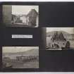
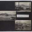
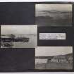
Photographic Record (1906)
Photographs taken during a visit by the Churches Commission in July 1906.
The photographs are available in PA 71.

