
Cowiemuir


Cairn (Period Unassigned), Stone Circle (Neolithic) - (Bronze Age)(Possible)
Site Name Cowiemuir
Classification Cairn (Period Unassigned), Stone Circle (Neolithic) - (Bronze Age)(Possible)
Canmore ID 16928
Site Number NJ36SE 1
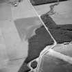
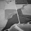
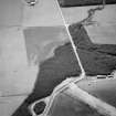
NGR NJ 3709 6310
Datum OSGB36 - NGR
Permalink http://canmore.org.uk/site/16928


- Council Moray
- Parish Bellie
- Former Region Grampian
- Former District Moray
- Former County Morayshire
NJ36SE 1 3709 6310
(NJ 3709 6310) Stone Circle (NR)
OS 6" map, (1959).
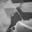
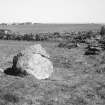
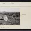
Two great stones remain nearly in situ on the terminations of an irregularly curved ridge, somewhat in the shape of a horsehoe. The ridge has an average height of about 2ft 6ins over the wide central portion. At the north end, and well within it, is a roughly circular hollow about 17ft in diameter. It it stony and uneven as is the larger area of ground between the edge of the hollow and the two stones. The stone on the east is a huge unshapely mass of conglomerate, probably a fallen stone. The stone on the west is a rough angular block of red granite.
Between the two stones the ground is flatter and smoother than elsewhere, almost suggestive of its having been used as the most convenient roadway, to and from the interior of the circle when it was destroyed. If this ridge carried the other stones of a circle, it would be of a size comparable only to that of the greater circle at Auchquhorthies at Kincausie. If the spacing of the other stones equalled that of the remaining two, the original circle would have consisted of six stones (F R Coles 1906).
F R Coles 1906.
A turf-covered robbed cairn, mutilated by ploughing, measuring c 21.0m in diameter and c 0.6m maximum height. Recent stone clearance has been added to the hollowed centre. Two contiguous earth-fast stones on the SW arc may have formed part of a kerb.
About 3.0m outside the cairn perimeter to the S are three irregular boulders, about 8.0m apart forming an arc. The westerly two are those described by Coles, the other is smaller. It is uncertain whether they form part of a circle or are merely fortuitous.
Resurveyed at 1/2500 (OS {N K B} 26 January 1965).
Visited by OS (N K B) 26 January 1965 and (R L) 14 May 1971.

