
Pricing Change
New pricing for orders of material from this site will come into place shortly. Charges for supply of digital images, digitisation on demand, prints and licensing will be altered.
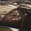
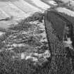
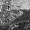
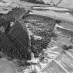
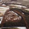
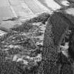
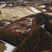
Shaw Hill


Rig And Furrow (Medieval) - (Post Medieval)
Site Name Shaw Hill
Classification Rig And Furrow (Medieval) - (Post Medieval)
Alternative Name(s) Bruce's Camp
Canmore ID 168826
Site Number NJ71NE 147
NGR NJ 7665 1894
NGR Description From NJ 7665 1894 to NJ 7696 1898
Datum OSGB36 - NGR
Permalink http://canmore.org.uk/site/168826


- Council Aberdeenshire
- Parish Kintore
- Former Region Grampian
- Former District Gordon
- Former County Aberdeenshire
NJ71NE 147 7665 1894 to 7696 1898
See also NJ71NE 3.
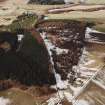
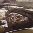
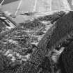
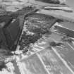
An extensive area of rig-and-furrow is visible within the fort on the summit of Shaw Hill (NJ71NE 3) and on the slopes immediately below the rampart on the S. The rigs are aligned NNE and SSW, those within the fort measuring up to 6m in breadth, and those on the S flank of the hill about 4m.
Visited by RCAHMS (JRS), 2 October 1996.

