Gauldwell Castle
Castle (Medieval)
Site Name Gauldwell Castle
Classification Castle (Medieval)
Alternative Name(s) Cauddwell Castle; Goldwell Castle; Gallvall Castle; Cauddwell Castle; Boharm Castle
Canmore ID 16841
Site Number NJ34NW 1
NGR NJ 3107 4515
Datum OSGB36 - NGR
Permalink http://canmore.org.uk/site/16841
- Council Moray
- Parish Boharm
- Former Region Grampian
- Former District Moray
- Former County Banffshire
NJ34NW 1 3107 4515.
(NJ 3107 4515) Cauddwell Castle (NR)
OS 6"map, (1959)
The ruins of Gallvall Castle, also known as Gauldwell (Name Book 1870) Boharm or Gouldwell Castle, reduced to the foundations, but apparently dating from the 1542 to 1700 period.
OSA 1796; Name Book 1870; D MacGibbon and T Ross 1887-92.
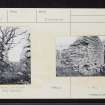
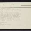
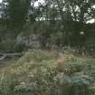
The remains of a castle, known locally as Gauldwell Castle, situated at the S end of a ridge sloping fairly gently to the S and steeply to the E and W. It is extensively ruined, particularly on the N, S and E sides, where only the inner wall face can be seen occasionally. The W wall, 2.5m thick, of random masonry roughly coursed with rubble infilling, survives to a height of 6.5m in places but is in danger of collapse. Internally the building measures 38.5m in length, 8.3m broad at the N end and 6.9m broad at the S end with a cross wall between. A base plinth is discernible at the N end of the W wall.
To the E of the castle is a level area probably a courtyard, in which can be seen the overgrown footings of a building, 9.0m by 4.0m. This abuts onto the remains of a wall which bounds the S side of the courtyard. All other traces of a surrounding wall have disappeared, save for a portion leading from the NE angle of the castle.
Simpson believes that Gauldwell Castle is a 13th century hall-house similar to Rait Castle ( ) and Shaw (L Shaw 1882) states that a castle was established in Boharm parish in the 12th century, probably on the site of the present ruined castle.
Revised at 1/2500
Visited by OS (N K B) 12 July 1967; L Shaw 1882; Information from Dr W D Simpson, Kings College library.
Copies of correspondence relating to unpublished excavations in the Castle in 1956 have been deposited in the Grampian Regional Council Sites and Monuments Record.
I Shepherd 1983.


