
Buchaam


Souterrain (Prehistoric)
Site Name Buchaam
Classification Souterrain (Prehistoric)
Alternative Name(s) Forbestown
Canmore ID 16784
Site Number NJ31SE 8
NGR NJ 3926 1324
Datum OSGB36 - NGR
Permalink http://canmore.org.uk/site/16784


- Council Aberdeenshire
- Parish Strathdon
- Former Region Grampian
- Former District Gordon
- Former County Aberdeenshire
NJ31SE 8 3926 1324
See also NJ31SE 87.
(NJ 3929 1321) Erd House (NR)
OS 6" map, 1903.
'Erd House. A very complete specimen of an Erd House discovered by Mr Walker, Gardener, Castle Newe in 1859. It is about 60 feet in length and shaped like a pear. It is in a good state of preservation and is kept under lock and key'.
Name Book 1866.
An earth-house at Buchaam was excavated by Alexander Walker, Castle Newe, in 1859. The road to the farm-steading passed over it and the farm-house was in close proximity to it.
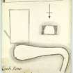
The chamber is pear-shaped on plan and is 58 feet long. At the NE corner was a large quantity of charcoal under a smoke hole and near it sheep and fowl bones. At the SE corner a drain led away under the corner of Buchaam House. Finds included iron objects, fragments of wood, animal bones, potsherds and a fragment of quern.
The earth-house has been restored with clay puddling and covered by an earth mound planted with trees and was under lock and key in 1866.
A Mitchell 1863; Name Book 1866.
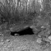
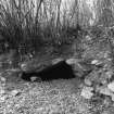
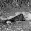
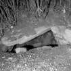
This earth-house has been extensively mutilated by the farmroad and an extension to the farmhouse of Buchaam (NJ31SE 87). The entrance is blocked and the only roofed portion is the short passage from the entrance to the chamber. The chamber is 0.8m high on its N side, and all that remains of the S wall is an occasional earthfast stone.
Re-surveyed at 1/2500.
Visited by OS (N K B) 29 August 1968.
Souterrain [NR]
OS 1:10,000 map, 1976.
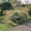
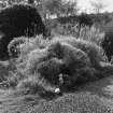
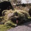
This souterrain is situated within a garden on a moderate slope in a large shelf at an altitude of about 280m OD.
(GRC/AAS ground photographs cited and copies of 1930's photographs by Dr J Johnstone noted).
NMRS, MS/712/43.
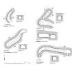
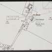
The souterrain that lies immediately to the N and NE of Buchaam farmhouse (NJ31SE 87) was discovered in 1859, when Buchaam formed part of the Newe Estate. It appears to have survived relatively intact until sometime this century when the SE part of the chamber was dismantled to make way for the extension that forms the NE end of the present farmhouse. The surviving roofed portion comprises is a short length of passage dipping down from the entrance, and a short length of the NW end of the chamber. The entrance itself is obscured by a relatively recent blocking of dumped stones, but the entrance passage measures about 3.5m in length by up to 1.2m in breadth. It descends steeply to a point where a pair of flanking jambs mark the beginning of the main chamber. This chamber measures up to 1.7m in breadth and 1.5m in height, it turns sharply eastwards immediately beyond the roofed section. Its dry-stone walls are constructed of mainly angular blocks interspersed with the occasional rounded boulder, and they are founded upon vertically-set grounders about 0.6m high; the top of the wall is corbelled immediately below a roof of large, irregularly-shaped slabs. Jumper-holes in two of these slabs indicate that the souterrain has been, at least in part, re-roofed, perhaps as part of the restoration mentioned in the Name Book.
The main chamber of the souterrain originally measured about 14m in length by up to 4.1m in breadth and 2.2m in height at the ESE end, but most of its S side and the roof were dismantled when the house extension was built. About 10m of the N side, however, with its corbelling surviving, has been retained as a low revetment wall along the S side of a path extending round the end of the house. The lower part of the S side of the chamber may have been incorporated into the foundations and basal courses of the house extension, and the modern path is probably as much as 1m, above the original floor of the souterrain.
The present whereabouts of the reported finds is not known.
Visited by RCAHMS (JRS, RJCM), 12 October 1998.
Name Book 1866.
Scheduled as Buchaam, souterrain, Forbestown.
Information from Historic Scotland, scheduling document dated 13 February 2001.

