 |
On-line Digital Images |
SC 1057267 |
RCAHMS Aerial Photography |
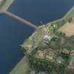
Scanned oblique aerial view of the junction between Mugdock (NS57NE.63) and Craigmaddie (NS57NE.61) Reservoirs including Mugdock Straining Well (NS57NE 63.05) and Chlorinating House (NS57NE 63.04) |
2/2003 |
Item Level |
|
 |
On-line Digital Images |
SC 1057268 |
RCAHMS Aerial Photography |
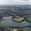
Scanned oblique aerial view of Mugdock (NS57NE.63) and Craigmaddie (NS57NE.61) Reservoirs |
2/2003 |
Item Level |
|
 |
On-line Digital Images |
SC 1057269 |
RCAHMS Aerial Photography |
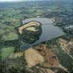
Scanned oblique aerial view of Mugdock (NS57NE.63) and Craigmaddie (NS57NE.61) Reservoirs |
2/2003 |
Item Level |
|
|
Photographs and Off-line Digital Images |
E 35130 CN |
RCAHMS Aerial Photography |
Oblique aerial photograph showing junction between Mugdock (left) and Craigmaddie Reservoirs (right) with straining wells visble |
2/4/2003 |
Item Level |
|
|
Photographs and Off-line Digital Images |
E 35132 CN |
RCAHMS Aerial Photography |
Oblique aerial photograph showing junction between Mugdock (left) and Craigmaddie Reservoirs (right) with straining wells visble |
2/4/2003 |
Item Level |
|
|
Photographs and Off-line Digital Images |
E 35133 CN |
RCAHMS Aerial Photography |
Oblique aerial photograph showing junction between Mugdock (left) and Craigmaddie Reservoirs (right) with straining wells visble |
2/4/2003 |
Item Level |
|
|
Photographs and Off-line Digital Images |
E 35135 CN |
RCAHMS Aerial Photography |
Oblique aerial photograph showing the gauge basins with their water inlets and measuring pond and sluice beyond of Mugdock Reservoir |
2/4/2003 |
Item Level |
|
|
Photographs and Off-line Digital Images |
E 35136 CN |
RCAHMS Aerial Photography |
Oblique aerial photograph showing the gauge basins with their water inlets and measuring pond and sluice beyond of Mugdock Reservoir |
2/4/2003 |
Item Level |
|
|
Photographs and Off-line Digital Images |
E 35140 CN |
RCAHMS Aerial Photography |
Oblique aerial view Craigmaddie Reservoir (left) and Mugdock Reservoir (right) |
2/4/2003 |
Item Level |
|
|
Photographs and Off-line Digital Images |
E 35142 CN |
RCAHMS Aerial Photography |
Oblique aerial view Craigmaddie Reservoir (right) and Mugdock Reservoir (left) and straining wells |
2/4/2003 |
Item Level |
|
|
Photographs and Off-line Digital Images |
E 35143 CN |
RCAHMS Aerial Photography |
Oblique aerial view centred on the reservoirs |
2/4/2003 |
Item Level |
|
|
Photographs and Off-line Digital Images |
E 35144 CN |
RCAHMS Aerial Photography |
Oblique aerial view centred on the reservoirs |
2/4/2003 |
Item Level |
|
|
Photographs and Off-line Digital Images |
E 35145 CN |
RCAHMS Aerial Photography |
Oblique aerial view centred on the reservoirs |
2/4/2003 |
Item Level |
|
|
Photographs and Off-line Digital Images |
E 35147 CN |
RCAHMS Aerial Photography |
Oblique aerial view centred on the reservoirs |
2/4/2003 |
Item Level |
|
|
Photographs and Off-line Digital Images |
E 35150 CN |
RCAHMS Aerial Photography |
Oblique aerial view |
2/4/2003 |
Item Level |
|
|
Photographs and Off-line Digital Images |
E 31742 CN |
RCAHMS Aerial Photography |
Oblique aerial photograph showing Mugdock Reservoir's measuring pond, footbridge and sluice. View looking E. |
2/4/2003 |
Item Level |
|
 |
On-line Digital Images |
SC 1389605 |
Records of the Royal Commission on the Ancient and Historical Monuments of Scotland (RCAHMS), Edinbu |
View of top of straining well from S |
13/9/2001 |
Item Level |
|
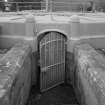 |
On-line Digital Images |
SC 1389606 |
Records of the Royal Commission on the Ancient and Historical Monuments of Scotland (RCAHMS), Edinbu |
Detail of entrance to straining well |
13/9/2001 |
Item Level |
|
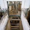 |
On-line Digital Images |
SC 1389607 |
Records of the Royal Commission on the Ancient and Historical Monuments of Scotland (RCAHMS), Edinbu |
Interior. View looking into centre of straining well |
13/9/2001 |
Item Level |
|
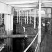 |
On-line Digital Images |
SC 1389608 |
Records of the Royal Commission on the Ancient and Historical Monuments of Scotland (RCAHMS), Edinbu |
Interior. View around perimeter of straining well |
13/9/2001 |
Item Level |
|
 |
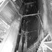
On-line Digital Images |
SC 1389609 |
Records of the Royal Commission on the Ancient and Historical Monuments of Scotland (RCAHMS), Edinbu |
Interior. View through middle of straining well |
13/9/2001 |
Item Level |
|
 |
On-line Digital Images |
SC 1389610 |
Records of the Royal Commission on the Ancient and Historical Monuments of Scotland (RCAHMS), Edinbu |
Interior. View looking down into bottom of empty straining well, which would normally be full of water |
13/9/2001 |
Item Level |
|
 |
On-line Digital Images |
SC 1389611 |
Records of the Royal Commission on the Ancient and Historical Monuments of Scotland (RCAHMS), Edinbu |
View from S of SE side of causeway, which faces onto Craigmaddie Reservoir |
13/9/2001 |
Item Level |
|
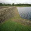 |
On-line Digital Images |
SC 1389612 |
Records of the Royal Commission on the Ancient and Historical Monuments of Scotland (RCAHMS), Edinbu |
Detail of masonry on the SE side of causeway, which faces onto Craigmaddie Reservoir |
13/9/2001 |
Item Level |
|


