
Pricing Change
New pricing for orders of material from this site will come into place shortly. Charges for supply of digital images, digitisation on demand, prints and licensing will be altered.
Glasgow, Possilpark Station


Railway Station (19th Century) - (20th Century)
Site Name Glasgow, Possilpark Station
Classification Railway Station (19th Century) - (20th Century)
Alternative Name(s) Possilpark And Parkhouse Station
Canmore ID 166296
Site Number NS56NE 1609
NGR NS 5875 6866
Datum OSGB36 - NGR
Permalink http://canmore.org.uk/site/166296


- Council Glasgow, City Of
- Parish Glasgow (City Of Glasgow)
- Former Region Strathclyde
- Former District City Of Glasgow
- Former County Lanarkshire
NS56NE 1609 5875 6866
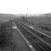
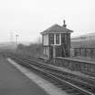
A 2 platform through station on a slight curve, with a goods yard on the south side. The buildings have been demolished, except for a small brick signal box of standard NBR pattern.
NMRS MS/749/5605.

