
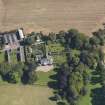
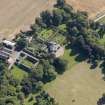
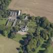
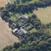
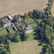
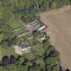
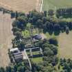
Pitmuies


Country House (Period Unassigned), Farmstead (Period Unassigned)
Site Name Pitmuies
Classification Country House (Period Unassigned), Farmstead (Period Unassigned)
Canmore ID 166193
Site Number NO54NE 69
NGR NO 5675 4980
Datum OSGB36 - NGR
Permalink http://canmore.org.uk/site/166193


- Council Angus
- Parish Kirkden
- Former Region Tayside
- Former District Angus
- Former County Angus
NO54NE 69 5675 4980
NO 5670 4983 An archaeological investigation was carried out of a mainly drystone well in August 2001. The well was discovered during the digging of a service trench in connection with restoration works of steadings (NMRS NO54NE 69) that form part of a Grade A listed group of buildings at House of Pitmuies (NMRS NO54NE 26).
The well capstones were discovered some 0.5m below a layer of hard-standing surface and made-up ground. The well was a more or less cylindrical structure (i.e. not tapering) and sub-circular in plan, measuring 1.12 x 1.15m, and penetrated the ground for approximately 4m. The uppermost course of stone walling directly beneath the two capstones covering the well shaft was mortared, as were the capstones. A timber beam appeared to have been embedded into the side of the well about halfway down the shaft. A small sample was retrieved and identified as coniferous; this may be significant in that the use of conifers as a building material only occurs after the late 17th/early 18th centuries.
Sponsor: Pitmuies Partnership.
D Rankin 2001a

