
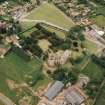
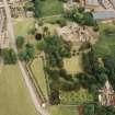
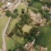
Dirleton Village Green


Building (Medieval)
Site Name Dirleton Village Green
Classification Building (Medieval)
Canmore ID 166131
Site Number NT58SW 79
NGR NT 5150 8402
Datum OSGB36 - NGR
Permalink http://canmore.org.uk/site/166131


- Council East Lothian
- Parish Dirleton
- Former Region Lothian
- Former District East Lothian
- Former County East Lothian
Geophysical Survey (11 August 2012)
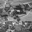
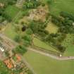
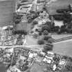
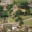
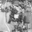
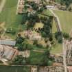
NT 51504 84041 (Green) and NT 51366 83992 (Paddock) In advance of a Scottish Archaeology Month event organised by the Gullane and Dirleton History Society a ground resistance survey of the village green and an adjacent paddock was undertaken, on 11 August 2012, to define earthworks on the green and to locate possible structures to the N of the Old Manse in the paddock. The earthworks on the green are thought to be the remains of a chapel associated with Dirleton Castle. The survey recorded linear low resistance traces of a rectangular structure around 22 x 10m with slightly rounded corners and a two cell rectangular structure of 14 x 11.5m to the N. These could be robbed out foundation trenches. The results in the paddock were inconclusive, probably due to tree roots drying out the subsoil although slight linear low resistance anomalies were noted.
Archive: RCAHMS and East Lothian Council SMR (intended)
Funder: East Lothian Council, Gullane and Dirleton History Society and Edinburgh Archaeological Field Society
Ian Hawkins, Edinburgh Archaeological Field Society
Donald Matthews, 2012
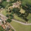
Field Visit (14 September 2012)
NT 5149 8403 A survey was undertaken on 14 September 2012 of earthworks on Dirleton Green. The work was carried out by East Lothian Council Archaeology Service and Gullane and Dirleton History Society as part of a training workshop during East Lothian Archaeology and Local History Fortnight. This work followed a geophysical survey of the site undertaken by EAFS (see above).
The plane table survey recorded the outline of two buildings at the E end of the green, which showed clearly as hollows, presumably where walls had been robbed. The first building was rectangular, aligned E–W and measured c22 x 11m. The second structure was less well defined, and showed as a low U-shaped mound, c13 x 11m. These results complement the geophysical survey which showed the clear outline of the two buildings.
Historical research undertaken by Gullane and Dirleton History Society suggests that these buildings could have been the site of a chapel or of a domestic or agricultural building. Nothing is shown on this site on Roy’s map of c1750, the first reasonably detailed map of this area, or on any subsequent map, suggesting that any buildings had gone out of use by that time. There are documentary references to two chapels in Dirleton, yet to be located, that existed in the medieval period but went out of use around the time of the Reformation. The plots around the green were feued in the 1630s. It is possible that the buildings were of a domestic/agricultural nature and did not fit the plan for the new plots.
Archive: RCAHMS (intended)
Stephanie Leith, East Lothian Council Archaeology Service
2012
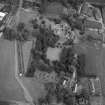
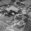
Excavation (12 September 2013 - 18 September 2013)
NT 5149 8403 A community excavation was undertaken, 12–18 September 2013, on the Green in Dirleton by East Lothian Archaeology Service, with Gullane and Dirleton History Society, as part of East Lothian Archaeology and Local History Fortnight.
The excavation followed an earthwork survey carried out with Gullane and Dirleton History Society and a geophysical survey of the site undertaken by EAFS in 2012. These surveys suggested that there were at least two buildings on the Green, which had disappeared by the time of Roy’s map in 1750.
The excavation uncovered one of the buildings, and showed that the other one did not exist. The building that was excavated appears to have been a substantial stone building, which was demolished in the 15th or 16th century. A number of interesting artefacts were found during the dig, including several thimbles, an early 17th-century pipe bowl and several coins including an 1895 silver thruppence. A number of sherds of medieval pottery were recovered from the demolition layers of the building.
During the five days of excavation, 70 volunteers took part in the dig, nearly 400 people visited the site, and 40+ school children from Dirleton got involved.
Archive: RCAHMS (intended)
Funder: East Lothian Council and The National Trust for Scotland
Stephanie Leith, East Lothian Council Archaeology Service, 2013
(Source: DES)
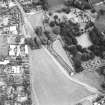
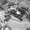
Excavation (8 September 2014 - 17 September 2014)
NT 5149 8402 A community excavation was undertaken, 8–17 September 2014, on the Green in Dirleton by East Lothian Council Archaeology Service, with Gullane and Dirleton History Society, as part of East Lothian Archaeology and Local History Fortnight.
The excavation followed an earthwork survey, geophysical survey and excavation in 2013. This year’s excavation aimed to further explore the site of a medieval building. To this end, an area of 10 x 5m was opened by hand, as well as a 5 x 1m trench and a 1 x 1m test pit.
The excavation uncovered the outline of the building represented by robber trenches, where the stone of the walls had been dug out and removed after the building went out of use. The site was infilled with dumps of rubble
after demolition of the building. A later wall suggests reuse of the site, possibly for industrial or agricultural use. Deposits of slag suggest that metal working was taking place somewhere nearby.
During the 10 days of excavation, 65 volunteers took part in the dig, over 400 people visited the site, and all the pupils from Dirleton Primary School and East Lothian Young Archaeology Club got involved.
Archive: RCAHMS (intended)
Funder: East Lothian Council
Stephanie Leith – East Lothian Council Archaeology Service
(Source: DES)

