
Pricing Change
New pricing for orders of material from this site will come into place shortly. Charges for supply of digital images, digitisation on demand, prints and licensing will be altered.
Short Sike


Boundary Bank (Period Unknown), Building(S) (Medieval) - (Post Medieval), Field System(S) (Medieval) - (Post Medieval), Rig And Furrow (Medieval) - (Post Medieval)
Site Name Short Sike
Classification Boundary Bank (Period Unknown), Building(S) (Medieval) - (Post Medieval), Field System(S) (Medieval) - (Post Medieval), Rig And Furrow (Medieval) - (Post Medieval)
Canmore ID 166093
Site Number NY48NE 188
NGR NY 4739 8703
NGR Description Centred on NY 4739 8703
Datum OSGB36 - NGR
Permalink http://canmore.org.uk/site/166093


- Council Scottish Borders, The
- Parish Castleton
- Former Region Borders
- Former District Roxburgh
- Former County Roxburghshire
Field Visit (16 April 1996)
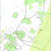
NY48NE 188 centred on 4739 8703
A series of discrete earthen-banked fields interspersed with patches of rough ground occupy a broken terrace to the S of the Short Sike. The fields are linked together by a later field-bank, but on the ESE they have been truncated by the Newcastleton crofts. Rig, measuring about 4m between furrows and often pinching together towards the ends, is visible on aerial photographs in the primary fields (543/RAF/1507 F22 frame no.0202, 3 November 1961). In places the rig overlies field-banks that subdivide the primary fields, but does not extend beyond the banks defining the upper edge of the system. A boundary bank butts on to the W side of these primary fields from the SW (NY 4731 8718) subdividing a large enclosure that takes in the E side of Kirk Hill and Park Hill (NY48NE 189.01). Another field, the interior of which does not seem to have been cultivated, lies on the N side of the Short Sike (NY 4741 8726).
The turf and stone footings of four buildings (LID96 281, 284, 286-7) and three huts (LID96 282-3, 285) are interspersed with the fields in four discrete groups. These may be farmsteads (NY 4735 8719, NY 4739 8703, NY 4736 8713, NY 4747 8686). With the exception of the southernmost (LID96 287), each comprising a single building and a hut. The buildings measure between 14.5m by 3.5m (LID96 284) and 8.3m by 3m (LID96 287) internally. Two have two compartments (LID96 281, 284) and there is a drain to deflect water along the upslope side of another (LID96 286). There are fragmentary enclosures beside all the buildings and the northernmost building (LID96 281) is overlain by a bank belonging to the primary fields. The huts measure between 2.6m by 1.9m (LID96 285) and 5m by 2.3m (LID96 282) internally.
(LID96 281-7)
Visited by RCAHMS (DCC) 16 April 1996

