
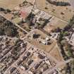
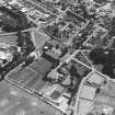
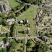
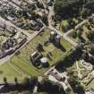
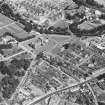
Elgin, North College Street, Elgin Cathedral, Chapter House


Chapter House (15th Century)
Site Name Elgin, North College Street, Elgin Cathedral, Chapter House
Classification Chapter House (15th Century)
Canmore ID 16587
Site Number NJ26SW 1.03
NGR NJ 2221 6307
Datum OSGB36 - NGR
Permalink http://canmore.org.uk/site/16587


- Council Moray
- Parish Elgin
- Former Region Grampian
- Former District Moray
- Former County Morayshire
NJ26SW 1.03 2221 6367
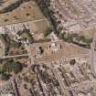
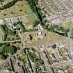
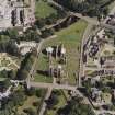
(NJ 2221 6307) Chapter House (NR)
OS 25"map (1871).
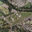
The Chapter House reconstructed in the 15th century, is the finest thing of its kind in Scotland. In the surviving ruins, and in the detached fragments assembled on the site, there is a wealth of moulded work, heraldic decoration, and figure sculpture, forming a notable conspectus of the medieval craftsman's art.
V G Childe and W D Simpson 1961.
As described and illustrated by V G Childe and W D Simpson 1961.
Visited by OS (R D L) 13 December 1962.
NJ 2211 6307 A watching brief was conducted in December 1999 in the cathedral chapter house (NMRS NJ26SW 1.03) while a cable trench was dug below the flagged floor, from the E side of the inner entrance to the chapter house, N to the central pillar and around to its W side. The flags appear to date to the late 15th-century remodelling of the chapter house, and were laid on a bedding of sand, gravel and crushed sandstone. No deposits below this were disturbed.
Sponsor: Historic Scotland
P Sharman 2000
Watching Brief (6 December 1999 - 7 December 1999)
A watching brief was conducted in the cathedral chapter house at Elgin, Morayshire. A cable trench was dug below the flagged floor, which ran from the E side of the inner entrance to the chapter house, N to the central pillar and around to its W side. The flags appear to date to the late 15th-century remodelling of the chapter house, and were laid on a bedding of sand, gravel and crushed sandstone. No deposits below this were disturbed.
Nothing of great significance was disturbed by the excavations. From the fact that the floor slabs abut the benching and that the pier foundations were clawed off, it would appear that the flagged floor is secondary, presumably laid during the late 15th-century building campaign (Fawcett 1994; 69). The worn and blackened state of the paving is likely to be a result of its use as well as a period of weathering when the inside of the building was exposed to the elements. John Slezer shows the chapter house roofless and with broken windows in Theatrum Scotiae, 1693 (reproduced in Fawcett 1997; 98). Interestingly, this is actually during the time that the building was used as a meeting-house (Richardson & Mackintosh 1950; 28). The floor is shown in situ by R W Billings in Baronial and Ecclesiastical Antiquities of Scotland published 1845-52, (Fawcett 1997; 74). There was not enough of the level sandstone fragment revealed in the hole at the W side of the pillar in order to permit a valid interpretation.
Sponsor: Historic Scotland
P Sharman 1999
Kirkdale Archaeology

