
Pricing Change
New pricing for orders of material from this site will come into place shortly. Charges for supply of digital images, digitisation on demand, prints and licensing will be altered.
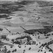
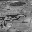
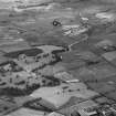
Glasgow, Bearsden, Killermont Golf Course


Golf Course (20th Century) (1904)
Site Name Glasgow, Bearsden, Killermont Golf Course
Classification Golf Course (20th Century) (1904)
Alternative Name(s) Killermount
Canmore ID 165735
Site Number NS57SE 165
NGR NS 56239 71054
NGR Description Centred on NS 56155 70892
Datum OSGB36 - NGR
Permalink http://canmore.org.uk/site/165735


- Council East Dunbartonshire
- Parish New Kilpatrick (Bearsden And Milngavie)
- Former Region Strathclyde
- Former District Bearsden And Milngavie
- Former County Dunbartonshire
NS57SE 56 centred 56155 70892

