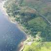
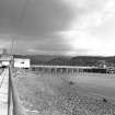
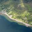
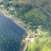
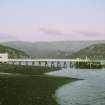
Accessibility

Font Size

100% 150% 200%

Background Colour

Default Contrast
Close Reset

Tighnabruaich, Pier

Pier (19th Century)

Site Name Tighnabruaich, Pier

Classification Pier (19th Century)

Alternative Name(s) Tighnabruaich, Steamer Pier; Kyles Of Bute

Canmore ID 165280

Site Number NR97SE 54

NGR NR 98600 73283

Datum OSGB36 - NGR

Permalink http://canmore.org.uk/site/165280

Ordnance Survey licence number AC0000807262. All rights reserved.
Canmore Disclaimer. © Bluesky International Limited 2025. Public Sector Viewing Terms

Toggle Aerial | View on large map

Digital Images

General oblique aerial view of Tighnabruaich, taken from the ENE.
General oblique aerial view of Tighnabruaich, taken from the ENE.Tighnabruaich, Pier
View from WSW showing SW frontGeneral oblique aerial view of Tighnabruaich, taken from the ESE.General oblique aerial view of Tighnabruaich, taken from the ENE.View from SW showing SW front of pierGeneral oblique aerial view of Tighnabruaich, taken from the ENE.

Administrative Areas

  • Council Argyll And Bute
  • Parish Kilfinan
  • Former Region Strathclyde
  • Former District Argyll And Bute
  • Former County Argyll

Archaeology Notes

NR97SE 54 98600 73283

Pier [NAT]

OS (GIS) MasterMap, January 2010.

References

MyCanmore Image Contributions


Contribute an Image

MyCanmore Text Contributions