
Pricing Change
New pricing for orders of material from this site will come into place shortly. Charges for supply of digital images, digitisation on demand, prints and licensing will be altered.
Upcoming Maintenance
Please be advised that this website will undergo scheduled maintenance on the following dates:
Thursday, 30 January: 11:00 AM - 3:00 PM
During these times, some functionality such as image purchasing may be temporarily unavailable. We apologise for any inconvenience this may cause.
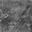
Glasgow, Kelvinhaugh Ferry, Kelvinhaugh Wharf


Wharf (19th Century) - (20th Century)
Site Name Glasgow, Kelvinhaugh Ferry, Kelvinhaugh Wharf
Classification Wharf (19th Century) - (20th Century)
Canmore ID 165246
Site Number NS56NE 1514
NGR NS 5628 6562
Datum OSGB36 - NGR
Permalink http://canmore.org.uk/site/165246


- Council Glasgow, City Of
- Parish Glasgow (City Of Glasgow)
- Former Region Strathclyde
- Former District City Of Glasgow
- Former County Lanarkshire
NS56NE 1514 5628 6562
Kelvinhaugh Ferry, Pointhouse Road to Highland Lane, opened c 1900 by the Clyde Navigation Trust. A standard passenger ferry.
John Hume 1974.
Desk Based Assessment (October 2001)
Archaeological desk based study carried out on Glasgow Harbour by FIRAT Archaeological Services.

