
Blackburn


Boundary Bank (Medieval) - (Post Medieval)
Site Name Blackburn
Classification Boundary Bank (Medieval) - (Post Medieval)
Alternative Name(s) Black Burn
Canmore ID 164933
Site Number NY48NE 183.01
NGR NY 4700 8918
NGR Description NY 4740 8867 to NY 4821 8960
Datum OSGB36 - NGR
Permalink http://canmore.org.uk/site/164933


- Council Scottish Borders, The
- Parish Castleton
- Former Region Borders
- Former District Roxburgh
- Former County Roxburghshire
Field Visit (29 February 1996)
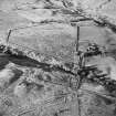
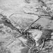
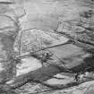
NY48NE 183.01 4740 8867 to 4821 8960
The sides and floor of the valley of the Black Burn are enclosed by a boundary comprising a bank with an external ditch on the upslope side; in places the ditch has been over deepened through erosion. The boundary runs W from the Bedda Cleugh (at NY 4740 8867) to a point beyond the Aldery Cleugh on the S side of the Black Burn (NY 4689 8896) before crossing to the N side of the valley and extending downstream as far as the Kiln Sike (beyond NY c.4734 8931); it may have formed part of a larger enclosure extending towards the Black Sike and the Ralton Burn (NY 4821 8960.
Visited by RCAHMS (DCC) 29 February 1996

