
Following the launch of trove.scot in February 2025 we are now planning the retiral of some of our webservices. Canmore will be switched off on 24th June 2025. Information about the closure can be found on the HES website: Retiral of HES web services | Historic Environment Scotland
Ben Cruachan, Dam


Dam (20th Century)
Site Name Ben Cruachan, Dam
Classification Dam (20th Century)
Alternative Name(s) Cruachan Pumped Storage Scheme; Ben Cruachan Hydroelectric Power Scheme
Canmore ID 164449
Site Number NN02NE 12.02
NGR NN 08015 28154
Datum OSGB36 - NGR
Permalink http://canmore.org.uk/site/164449


- Council Argyll And Bute
- Parish Ardchattan And Muckairn (Argyll And Bute)
- Former Region Strathclyde
- Former District Argyll And Bute
- Former County Argyll
NN02NE 12.02 08015 28154
Location formerly cited as NN 0786 28721 to NN 0815 2809.
Cruachan Dam [NAT]
OS 1:10,000 map, 1974.
The location assigned to this record defines the approximate midpoint of its length. The available map evidence suggests that it extends from NN c. 07871 28215 to NN c. 08159 28098.
Information from RCAHMS (RJCM), 17 May 2006.
Field Visit (2010)
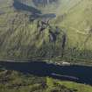
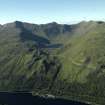
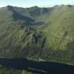
Cruachan Dam is a good example of the buttress type dam pioneered by James Williamson in his work at Sloy. The dam creates a reservoir for Ben Cruachan Power Station, the turbine hall of which lies buried in the hillside beneath the dam. The dam also receives and stores water pumped up from Loch Awe, as Cruachan operates as a pumped storage station with reversible turbines. Ben Cruachan dam is a fine example of the work of prominent dam designer James Williamson, characteristic of a large suite of dams he designed for major hydro electric power schemes in Scotland. The dam forms an integral part of one of the most innovative hydro electric schemes in Britain and the first example of integrated pumped storage technology. The dam dominates the corrie below Ben Cruachan itself and creates a large reservoir. The development of the scheme was a key component of the North of Scotland Hydro Electric Board’s (NoSHEB) plans to exploit the natural resources of Highland Scotland to generate electricity. National Archives of Scotland (NAS), Ref: NSE North of Scotland Hydro Electric Board Collection (1943 -1990); NAS, Ref: NSE1 North of Scotland Hydro Electric Board Minutes (1943-1990); NAS, Ref NSE2 North of Scotland Hydro Electric Board Annual Reports (1943-1990); PL Payne, 1988; E Wood, 2002,178-79; J Miller, 2002, 230-40; F A Walker, 2000, 375.
Note (25 October 2023)
Loch Awe Scheme was built between 1959 and 1967 and comprised three power stations Inverawe, Nant and Cruachan, the latter two being underground. Inverawe is supplied by a tunnel from Loch Awe and discharges into Loch Etive, whereas Nant is fed from Loch Nant by a tunnel supplemented by an aqueduct collecting from local streams and discharges into Loch Awe. These stations have installed capacity of 25MW and 15MW respectively.
By far the largest Power station in the scheme is Cruachan at 400MW and is a pumped storage system, making use of Cruachan Reservoir at an altitude of 1316 feet to give a head of 1198 feet. During off-peak periods at night and at week-ends, water is pumped up to the reservoir from Loch Awe using available excess power. The water is used to generate during daytime demand, discharging into Loch Awe.
The project involved the design and development of special turbines that could be utilized as pumps against a high head of water, and alternators that could be driven as motors. A buttress dam was built at the exit end of Cruachan Reservoir, and several tunnels to collect water from the surrounding area. Problems at the lower level were largely caused by congestion at the Pass of Brander, leading to the decision to build the power station in the heart of Ben Cruachan. This involved an enormous amount of excavation , made difficult by geological problems. Later on problems arose due to the necessity to assemble large machinery in confined space under controlled conditions. Also difficulties were encountered with the outfall into Loch Awe. However, in spite of the difficulties the project was successfully completed to specification in 1967.
Information from NRHE catalogue item number WP007424 compiled by George Walker in 2005.
Publication Account
Cruachan is part of the Awe scheme designed by James Williamson & Partners for the North of Scotland Hydro- Electric Board, and is a 440MW reversible pumped
storage development. It was built from 1959–65 and was the first large pumped storage installation in Scotland.
The operating head between the reservoir on Ben Cruachan and Loch Awe is 1200 ft, the highest in the world for this kind of plant. The power station and machine-hall are entirely underground, located in a cavern 300 ft long and 120 ft high hewn out of the rock of the mountain.
The upper dam is of the massive buttress-type containing 115 900 cu. yards of concrete. It is 1037 ft long with a greatest height of 153 ft and crest 1315 ft above sea level.
Generation of electricity is timed to occur during daytime peak loads on the supply system, using water flowing from the reservoir down to Loch Awe. Pumping is
carried out mostly at night and at weekends, using surplus energy from steam generating stations elsewhere.
The turbines are rotated in a reverse direction and lift the water from Loch Awe up to the reservoir on Loch Cruachan.
The tail-race from the power station runs into Loch Awe not far from a visitor centre at the loch side with displays illustrating the scheme.
The A85 Tyndrum to Oban trunk road runs past the visitor centre. From 1967–74 the road was reconstructed and realigned on a reinforced concrete viaduct cantilevered out over, and with supporting columns in, Loch Awe. This work, of considerable technical difficulty, avoiding interference with the Callander & Oban Railway which ran along the hillside some 50 ft above, is comparatively unknown. The engineers were W. A. Fairhurst and Partners and the contractors, Balfour Beatty.
R Paxton and J Shipway 2007b
Reproduced from 'Civil Engineering heritage: Scotland - Highlands and Islands' with kind permission of Thomas Telford Publishers.

