|
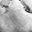
Photographs and Off-line Digital Images |
C 72914 |
RCAHMS Aerial Photography |
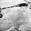
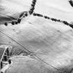
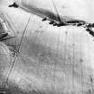
Old Town of Leys, oblique aerial view, taken from the SE, centred on the cropmarks of a palisaded enclosure. |
16/7/1996 |
Item Level |
|
|
Photographs and Off-line Digital Images |
C 72915 |
RCAHMS Aerial Photography |
Old Town of Leys, oblique aerial view, taken from the SE, centred on the cropmarks of a palisaded enclosure. |
16/7/1996 |
Item Level |
|
|
Photographs and Off-line Digital Images |
C 72916 |
RCAHMS Aerial Photography |
Old Town of Leys, oblique aerial view, taken from the NE, centred on the cropmarks of a palisaded enclosure. |
16/7/1996 |
Item Level |
|
|
Photographs and Off-line Digital Images |
C 72917 |
RCAHMS Aerial Photography |
Old Town of Leys, oblique aerial view, taken from the N, centred on the cropmarks of a palisaded enclosure. |
16/7/1996 |
Item Level |
|
 |
Digital Files (Non-image) |
WP 003643 |
Stuart Farrell |
Report of Archaeological Desktop & Walkover Survey, for Young Associates Ltd, of the Inverness Flood Relief Scheme.
|
6/2004 |
Item Level |
|
 |
On-line Digital Images |
SC 1695870 |
RCAHMS Aerial Photography |
Old Town of Leys, oblique aerial view, taken from the SE, centred on the cropmarks of a palisaded enclosure. |
16/7/1996 |
Item Level |
|
 |
On-line Digital Images |
SC 1695871 |
RCAHMS Aerial Photography |
Old Town of Leys, oblique aerial view, taken from the SE, centred on the cropmarks of a palisaded enclosure. |
16/7/1996 |
Item Level |
|
 |
On-line Digital Images |
SC 1695872 |
RCAHMS Aerial Photography |
Old Town of Leys, oblique aerial view, taken from the NE, centred on the cropmarks of a palisaded enclosure. |
16/7/1996 |
Item Level |
|
 |
On-line Digital Images |
SC 1695873 |
RCAHMS Aerial Photography |
Old Town of Leys, oblique aerial view, taken from the N, centred on the cropmarks of a palisaded enclosure. |
16/7/1996 |
Item Level |
|
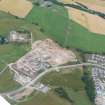 |
On-line Digital Images |
DP 340669 |
Papers of James Sloan Bone, landscape historian, Inverness, Highland, Scotland |
Oblique aerial view of Culduthel Farm development, Inverness, looking SW. |
6/8/2006 |
Item Level |
|
 |
On-line Digital Images |
DP 342598 |
Papers of James Sloan Bone, landscape historian, Inverness, Highland, Scotland |
Aerial view of Culduthel Mains Avenue, Inverness, looking E. |
3/2/2012 |
Item Level |
|
 |
On-line Digital Images |
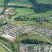
DP 342807 |
Papers of James Sloan Bone, landscape historian, Inverness, Highland, Scotland |
Aerial view of Slackbuie, Inverness, looking N. |
2/6/2012 |
Item Level |
|
 |
On-line Digital Images |
DP 342808 |
Papers of James Sloan Bone, landscape historian, Inverness, Highland, Scotland |
Aerial view of Culduthal area of Inverness, looking N. |
2/6/2012 |
Item Level |
|
 |
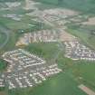
On-line Digital Images |
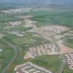
DP 343091 |
Papers of James Sloan Bone, landscape historian, Inverness, Highland, Scotland |
Aerial view of Culduthel housing development and Inverness Ring Road, Inverness, looking SE. |
16/8/2013 |
Item Level |
|
 |
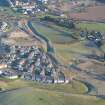
On-line Digital Images |
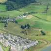
DP 343093 |
Papers of James Sloan Bone, landscape historian, Inverness, Highland, Scotland |
Aerial view of Oldtown of Leys House and Farm Steading, Inverness, looking SE. |
16/8/2013 |
Item Level |
|
 |
On-line Digital Images |
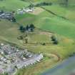
DP 343094 |
Papers of James Sloan Bone, landscape historian, Inverness, Highland, Scotland |
Aerial view of Oldtown of Leys House and Farm Steading, Inverness, looking SE. |
16/8/2013 |
Item Level |
|
|
All Other |
551 104/16/83 |
Records from Headland Archaeology Ltd, archaeologists, Edinburgh, Scotland |
Archive from archaeological evaluation and excavation at Culduthel Farm, Inverness, Highlands |
17/5/2005 |
Sub-Group Level |
|


