
Pricing Change
New pricing for orders of material from this site will come into place shortly. Charges for supply of digital images, digitisation on demand, prints and licensing will be altered.
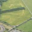
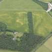
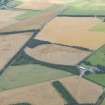
Balblair


Geological Cropmark(S) (Period Unknown), Pit(S) (Period Unassigned)(Possible)
Site Name Balblair
Classification Geological Cropmark(S) (Period Unknown), Pit(S) (Period Unassigned)(Possible)
Canmore ID 163575
Site Number NH85NE 436
NGR NH 8723 5512
Datum OSGB36 - NGR
Permalink http://canmore.org.uk/site/163575


- Council Highland
- Parish Nairn
- Former Region Highland
- Former District Nairn
- Former County Nairn
NH85NE 436 8723 5512.
Most of the cropmarks in this field are probably geological in origin, but there may be some pits amongst the background noise.
Information from RCAHMS (DCC) 27 November 2014

