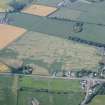
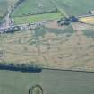
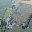
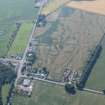
Accessibility

Font Size

100% 150% 200%

Background Colour

Default Contrast
Close Reset

Glenlochar

Field Boundary(S) (Period Unassigned)

Site Name Glenlochar

Classification Field Boundary(S) (Period Unassigned)

Canmore ID 163419

Site Number NX76SW 49

NGR NX 74158 64698

Datum OSGB36 - NGR

Permalink http://canmore.org.uk/site/163419

Ordnance Survey licence number AC0000807262. All rights reserved.
Canmore Disclaimer. © Bluesky International Limited 2025. Public Sector Viewing Terms

Toggle Aerial | View on large map

Digital Images

Glenlochar, oblique aerial view, taken from the NW, centred on the cropmarks of field boundaries.
Glenlochar, oblique aerial view, taken from the NW, centred on the cropmarks of field boundaries.Glenlochar, oblique aerial view, taken from the E, centred on the cropmarks of field boundaries.Glenlochar, oblique aerial view, taken from the NE, centred on the cropmarks of field boundaries.Glenlochar, oblique aerial view, taken from the NW, centred on the cropmarks of field boundaries.Oblique aerial view.Glenlochar, oblique aerial view, taken from the N, centred on the cropmarks of field boundaries.Oblique aerial view.Glenlochar, oblique aerial view, taken from the E, centred on the cropmarks of field boundaries.Oblique aerial view.Oblique aerial view.

Administrative Areas

  • Council Dumfries And Galloway
  • Parish Crossmichael
  • Former Region Dumfries And Galloway
  • Former District Stewartry
  • Former County Kirkcudbrightshire

Archaeology Notes

NO76SW 49 741 646

Information to follow.

RCAHMS (KB), 26 June 2000.

Activities

Aerial Photographic Transcription (13 March 2012)

These field boundaries have been recorded as cropmarks on oblique aerial photographs (RCAHMSAP 1996). They are depicted on the 2nd edition of the OS 6-inch map (Kirkcudbrightshire 1910-11, sheet 72NX76sw).

Information from RCAHMS (KHJM) 13 Mar 2012

References

MyCanmore Image Contributions


Contribute an Image

MyCanmore Text Contributions